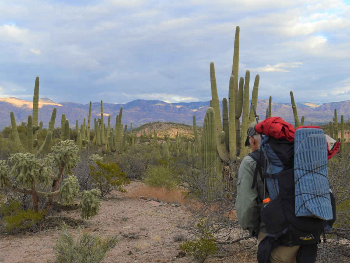

The Arizona Winter Traverse is a new 460 mile route across southern Arizona, starting on the Colorado River just south of Lake Havasu and finishing at the New Mexico border near the little town of Duncan. It crosses public lands: Bureau of Land Management, Arizona state lands, and Forest Service, including multiple wilderness areas. What little hiking trail the route follows is almost entirely in the Table Top Wilderness and in the Galiuro Mountains. Most of the route is cross country or on little-used 4WD roads. There are two day-long road walks near Casa Grande and west of Hwy 191.
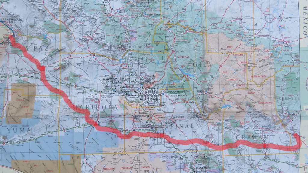
Below is a Google Map from which you can download the route and also potential water sources, resupply places, and points of special interest.
https://www.google.com/maps/d/edit?mid=1XWh-C1uzelIiPQrjabRZQT8ufAY93acC&usp=sharing
My intent for this route was to have a trail that could be hiked in mid-winter in a relatively short time frame for a thru-hike. The maximum elevation is about 6,700 feet, so my hiking partner “Wyoming” and I only encountered snow once. It would be far too hot to do this route during the summer, but during our hike, which lasted a month, December 28, 2021 to January 28, 2022, the maximum temps were about 80. Most nights it froze, with the coldest night being about 20. Usually it would be just below freezing at night.
Days are short mid-winter, about 10 hours of sun and 11 hours maximum of usable hiking light, so our average hiking days were in the 16 mile range. There is less climbing on this trail than many long routes, but lack of trail and route finding slows hiking somewhat.
Food and Water:
We did multiple water/food caches because we were unsure of water sources. There were no bears where we cached, but we assumed all our caches would be investigated by critters such as coyotes and rodents or perhaps stumbled across by people. We didn’t see any immigrants, but saw evidence of them in many places. Immigrants or even border patrol might destroy or remove any discovered caches. All caches were hidden and/or buried. Not a bad idea to leave a note with caches describing who you are and why you placed them. In two places we cached food in bear canisters, and in one place a five gallon bucket. Multiple caches contained a variety of canned food. We flattened and carried the cans until they could be disposed of. This wasn’t as inefficient as it might seem because we were forced to carry water weight regardless. We got rid of all trash on hand at our empty canister or bucket caches or ASAP. All cache sites were photographed and carefully marked by GPS by both Wyoming and me. It’s smart to record the exact contents of each cache. Along with food and water, consider treats or other consumables you might want to stash.
During our hike we found many cattle tanks and wildlife waterers and a handful of natural sources, although sometimes they were 20 miles or more apart. I think it would be possible to do the entire hike without caches on an average year for a hiker with desert experience and good judgment and water management skills. I think the longest distance between water is at the west end of the route, nearly 30 miles, IF the cattle tank at the end has water. The Hayden-Rhodes aqueduct is tempting, and it would be possible to get under or over the fence and crawl down one of the ladders to get water, but there would be some risk and getting prosecuted would be a possibility. Coming out of the Gibraltar Mountain Wilderness in this stretch there were a number of RV campers and it would probably be easy to get some water from one of them. Caching water is an option too. For myself, I found I could usually get by with carrying three quarts of water a day on this hike, drinking extra water at sources. The most either of us ever carried was about 8 quarts, but that was rare. It’s important to never get dehydrated regardless.
If I were doing the hike again I’d do the whole thing without caches or hitching, just for the challenge. Most people will probably want to put out a few caches and/or do the hitch into Safford to shorten a long food carry. I would not recommend this route for beginners. Water sources we found may not be available when the next hikers pass through, or might even be misplotted. Always have a “Plan B” like hiking out to a highway if necessary.
Approximate distances between food resupply:
Colorado River>60 Miles<Salome>110 miles<Gila Bend>85 miles<Arizona City>8 miles<Eloy>57 miles<Oracle>95 miles<Hwy 191 (hitch to Safford)>53 miles<Duncan
We had cell phone coverage for most but not all of this route. We once went five days without seeing anyone. A hiking partner or a satellite communicator like an inReach or Spot is highly recommended.
Dress for for the sun. We wore long-sleeve shirts and long pants. Sunscreen is a good idea for faces and hands. We wore light trail shoes. Choose shoes with harder soles and watch your footing to avoid cactus. Carry tweezers. We saw no snakes that time of year.
I’d recommend Gaia GPS premium, with the following maps along the route downloaded to your device before the hike: Satellite with Labels, USGS Topo, Public Lands, and a low resolution Cell Coverage map. Do not blindly follow the line on the map as it is approximately the route we hiked, not the exact line. You’ll often want to vary where you hike based on vegetation and topography and your personal preferences. Would you rather hike a jeep trail or a wash or cross-country? Your choice!
We got two types of permits, a permit for Arizona state lands, and a permit for the Sand Tank Mountains in the Sonora National Monument.
Watch the video to get an idea of the route. Give it a like if you enjoy it. Questions? Ask below.