
Farm Country
It was near freezing last night with the humidity near 100%. Moisture condensed on the outside of my sleeping bag but I slept warm. Many coyotes were howling at times. Cliffs lined the right side of the trail for most of the day and I …
Thru-hiking, paddling, climbing, hunting, fishing, gear lists, tips, and more.

It was near freezing last night with the humidity near 100%. Moisture condensed on the outside of my sleeping bag but I slept warm. Many coyotes were howling at times. Cliffs lined the right side of the trail for most of the day and I …

I slept great and woke up early. I packed in the first gray light and began to follow the bicycle trail that runs along the river. There were many deer and hundreds of ducks and greese, even wild turkeys. I passed a lock and dam …

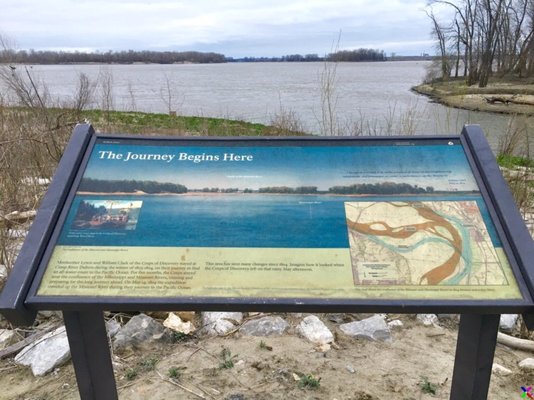
Hartford, Illinois
My old smokejumper buddy Ken Coe picked me up at midnight. I locked the door of my cabin and caught the plane to Seattle.
After breakfast, I boarded my next flight to Minneapolis. In all my many years of flying around the West I don’t think I’ve ever had a good look at Great Falls from air, but today I could easily pick out my long portage around the falls and dams, months and perhaps 2,000 miles in the future.
I had to make a long run in Minneapolis, and I mean run, to catch my final leg to St. Louis. I barely made it at that.
Scott Mandrell was right on time picking me up. A friendly, intelligent fellow, he is a fountain of information on the Trail, having portrayed Lewis in the epic reenactment of the expedition. He showed me around Camp Dubois and then dropped me of near the confluence of the Mississippi and Missouri.
I walked down to the water and stood for a few minutes looking at this significant place. I’d last seen this sight when I canoed the Mississippi fifteen years ago. I walked just far enough to find a good place to camp.
It’s a cloudy, dark night. Frogs are singing, and the cottonwoods are creaking in a light wind.
Clark, May 14, 1804 Set out from Camp River a Dubois at 4 oClock P.M. and proceded up the Missouris under Sail to the first Island in the Missouri and Camped on the upper point opposit a Creek on the South Side below a ledge of limestone rock Called Colewater, made 4 1/ 2 miles, the Party Consisted of 2, Self one frenchman and 22 Men in the Boat of 20 ores, 1 Serjt. & 7 french in a large Perogue, a Corp and 6 Soldiers in a large Perogue. a Cloudy rainey day. wind from the N E. men in high Spirits
Check out my latest location. Click on the placemark for more info.