
CLICK HERE FOR MY FIRST JOURNAL POST
In the summer of 2016 I retraced the route of Lewis and Clark by kayak and on foot.
Years ago, when I was planning to hike the Appalachian Trail, I learned of the tradition of “trail names.” Most hikers adopt a name they will be known by on their journey. Some names are bestowed by fellow hikers, others are chosen. I was just finishing up a book about John Colter, a hunter and member of the Lewis and Clark expedition. After two years of wilderness exploration with the Corp of Discovery, Colter headed back to the Rockies before they had even returned to St. Louis. I admired his spirit, so I chose his name, Colter, as my trail name, a name I have used on subsequent long trails. Little did I know I would attempt Colter’s westward journey myself one day.
I started at at the confluence of the Mississippi and Missouri rivers near St. Louis. I walked the first 800 miles or so to avoid the hundreds of wing-dams on the lower river. These dams force an upstream paddler into very fast current in the middle of the river, or through the potentially hazardous currents flowing over the wing-dams.
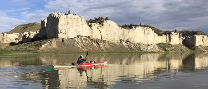
My kayaking gear was stored at Yankton. There I started paddling up the Missouri River as far as Three Forks, Montana, approximately 1,510 river miles. From Three Forks I followed the Lewis and Clark Trail on foot, up the Jefferson and Beaverhead Rivers, then over Lemhi Pass to Salmon, Idaho. I crossed Lost Trail Pass to Lolo, Montana. From there I crossed Lolo Pass, following the Lolo Trail/Lewis and Clark Trail/Nez Perce Trail to Canoe Camp on the Clearwater River, nearly 500 miles. It was about 513 river miles from Canoe Camp down the Clearwater, Snake and Columbia Rivers, to the Pacific. The total mileage was about 3,323 miles.
All forward progress along the route was by foot or by kayak. If I got a ride to a grocery store, for example, I returned to where I left the route to proceed under my own power. I did all of my own portages, the longest about 20 miles at Great Falls, which was also Lewis and Clark’s longest portage. Like Lewis and Clark, I left my boat in Montana, unlike them I didn’t use horses for crossing the Rockies and craft a new boat, I hiked and had a friend haul my kayak to the Clearwater River.
I began my journey March 24, 2016.
You can see my hiking gear list here.
My kayaking gear list is here.
You can see my progress on the below map.
Want to jump to another date or place in my journal? Scroll through the Calendar, (make sure you have the right year!) or use “Search,” both at the bottom of the page.
I also have a new video about my adventure. Please check it out!
Thanks for visiting! Buck aka “Colter”
Bruce:
Holler if you need some support in Salmon. Even Colter enjoyed a hot bath once in awhile. Or so they said.
Tony
Thanks Tony. It would be great to see you.
For those who don’t know him, Tony fought wildfires in Alaska, which is where I met him. He was also a game warden for many years and is now a successful author as well. Check out his website.
Hey Tony, that shot of you on the motorcycle, is that the Tanacross runway?
Yeah, it is. You probably Volpar’d in and out of there more than a time or two.
Did some standby there with the Razorbacks too. As I recall, you often quoted Arlo about your “motorsickle.”
Very exciting trip. Wish I could do it. Good Luck! I’ll be following your journey.
Thank you Mark!