July 28, Day 127, Mile 2321 Today was a landmark day, the day I reached the headwaters of the Missouri and the end of my long journey upstream along this longest river in America. In the morning I was on my last map page of …
July 27, Day 126, Mile 2309 There were often mountain ranges in sight today, but on a twisting river and seeing them from an unfamiliar perspective I couldn’t identify them with certainty, but one range might have been the Madisons. There were stretches of river …
It was a short, tough, adventurous day.
There was a heavy dew last night but the morning was sunny. At first the going wasn’t too bad, with stretches where I could paddle and decent wading in places where I had to get out and pull.
In less than three hours I saw Willow Coulee landing ahead. Sometimes people get a shuttle there to avoid the significant rapids below the dams. Most who get a shuttle go to Carter Ferry, probably the best option for the driver and most paddlers.
I checked out a sign at the landing. It said it was about an 8 hour float from Morony Dam to Fort Benton. 8 hours?! It will end up being three days for me heading upstream.
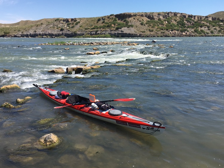
There was a rapids not far upstream of Widow Coulee. It was easy to line around the west side. As I traveled upstream, however, lining the rapids got more problematic. Over and over I ran across places where there were boulders on the bank and deep, fast water next to them. Sometimes there were numerous big rocks with water rushing between them and I’d have to figure out a way to thread the boat through them without getting it pinned in the rushing water or damaging it on sharp rocks.
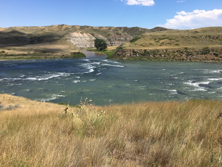
It was exciting to see Belt/Portage Creek up ahead. Here is where the Corps lined up the creek and then headed cross country on their portage. I had looked at this area many times on the map during planning, now it was transformed into real life.
Just above, on the other side of the river, was Sulphur Springs, sometimes called Sacajawea Springs. I climbed up to check it out. The history signs were interesting. Water from this spring was used to treat Sacajawea. The water was cool, not hot as I expected. A sign there questioned whether the party cared about her and her baby beyond her function as an interpreter, disappointingly cynical I thought and certainly untrue. Clark even ended up adopting the child after she died about ten years later.
Back at the bluff there was a nice view of Portage Creek and many rapids pouring over rock shelves and around boulders.
Missouri River rapids and Portage Creek
There were lining challenges upstream. The greatest were where I’d have to work the kayak around a boulder when it was too deep to wade and I couldn’t reach out far enough to pull the boat clear. Once the boat started filling with water before I could straighten it out. I fell in up to my armpits another time.
Looking at the ledges and boulders and wild hydraulics in places, I wouldn’t care to run this rapids downstream in a canoe or kayak without a lot of scouting and probably some lining.
Progress was slow. Seeing the bluffs and rapids ahead I hoped there wasn’t a spot that was both unlineable and unpaddleable.
Slowly working the boat around one big boulder in an especially fast spot the kayak started leaning. With so little freeboard it didn’t take much tipping for water to start running in. Water started pouring in faster and faster. I held on until I heard an ugly crunch. I let the boat back downstream, with the cockpit half full of water.
I dumped out most of the water and with some trepidation rolled it over to check out the damages. There was a 3″ crack, significant but not serious by the looks of it. But it would definitely need repairing.
Finally I could see Morony Dam ahead, and then the boat launch. I actually got to paddle the last two or three hundred yards.
A uniformed lady was picking up trash at the landing. I tried to catch her and ask about camping but she drove away. As I unloaded the boat a law enforcement officer stopped. I explained my situation and she thought it was a pretty cool trip, asking lots of questions. She suggested camping below high water just down from the landing somewhere. Camping isn’t allowed at the dam. So that’s what I did.
It was only a 7 mile day but those were some tough miles, with by far the most serious series of rapids I’ve seen on the Missouri River.
Tomorrow is the big portage which will take the whole day, at least. With all the resupplying, and now boat repair, I have to do I’ll probably spend two nights in Great Falls so I can relax a little bit as well.
July 16, Day 115
In the morning I separated all my gear and supplies into two piles, light and heavy. I packed the very heaviest items far aft in the rear compartment of the kayak, and other heavy items in my frameless backpack which I clipped and strapped on top of the back of the kayak. A few of the very lightest things I put in the front compartment.
I assembled the cart and slipped it on the boat. The load was so well balanced It only took a few pounds of lifting to pick up the bow.
I tied a 6″ loop of parachute cord to the bow handle, then slipped half my paddle through the loop. The loop should give me just enough extra distance to keep the kayak from bumping my legs as I pulled, and the paddle shaft would let me pull with two hands. It was about 600 vertical feet up to the top of the flats above.
Double checking to make sure I had everything I headed up the road. With very little food and only a gallon of water, the whole load was probably just a bit over 100 lbs: boat, cart, everything.
The road was hard packed gravel, with reasonable switchbacks and grade. The cart pulled remarkably easy. It was a cool, almost chilly morning with a light breeze, perfect weather for the task. Not, so far, the roasting late July/early August day I’d imagined for the portage months ago. I spotted a bedded mule deer buck watching me. When he jumped up to run two other bucks joined him.
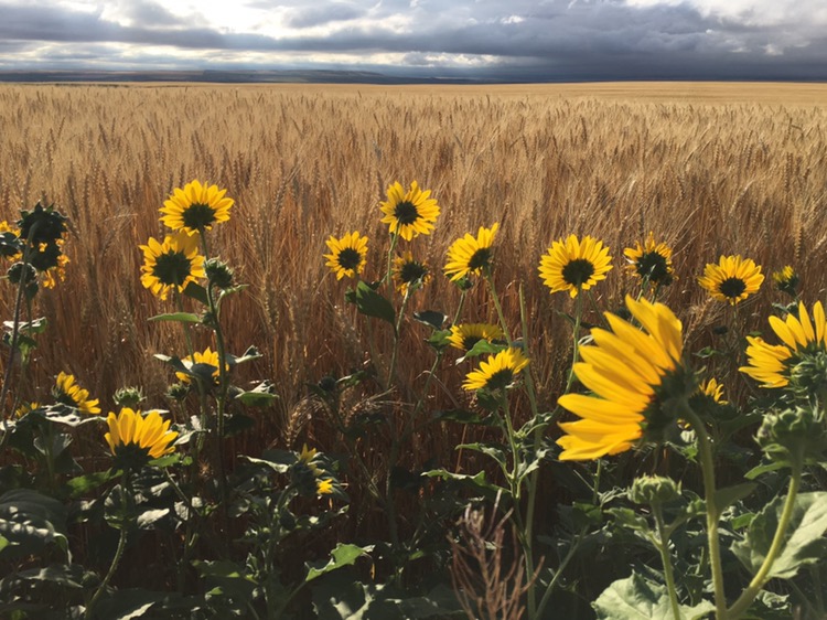
Things went so well that I’d climbed about 400 feet and gone about two miles when I stopped for my first break. The landscape was beginning to flatten into fields. I was surprised to see nearly mature wheat blowing in the breeze, with wild sunflowers on the field edges, facing the rising sun.
Wild Sunflowers and Wheat
The gravel turned to pavement. I could now walk at nearly a normal pace where it was flat. Soon I’d come 5 miles. An SUV pulled up. A young guy with fishing gear asked if I wanted any help. A few miles later a pickup pulling a load of big rafts offered me a ride on their way back, until I told them about my personal goals for the trip.
The sun came out and it got fairly hot. I passed a beautiful wheat ranch. Their home was in their own little shady woods, a lush oasis of protection from summer sun and winter winds.
After a few hours my route turned off onto a gated dirt road. Oh-oh. The sign said bikes and pedestrians were allowed. Yes! A Northwestern truck, the company that runs the dams, pulled up to make sure I wasn’t headed for Morony Dam by mistake (from where I’d just come.) That was mighty nice of him. A very friendly fellow. Everyone was surprised I was going upstream.
It was much hotter now and the gravel road was rolling and not as easy. This road was almost completely traffic-free though, and scenic, with views of the river and sage-grass hillsides. A mule deer doe and two small fawns bounded away. In places I could see Great Falls up ahead.
I passed Cochrane Dam and finally Rainbow Dam. A sign said it produced enough electricity for 54,000 homes.
It was a relief to reach pavement again. Another Northwestern truck offered to complete the shuttle for me. Then a car stopped to offer help. Very friendly, considerate people.
At about 14 miles I reached the Rainbow Dam boat launch. I put the cart on top of the boat and tested stability of my kayak, now that it was so top heavy. It be fine for the short crossing.
I paddled across and upriver to Giant Springs. People were enjoying their weekend on the paths around this scenic spot. The clear Roe River springs out of the ground here and only travels 200 feet before reaching the Missouri!
I wheeled my cart across the little bridge and then along the Missouri. Many little kids were fascinated by the spectacle.
At the Lewis and Clark Interpretive Center I had to leave my kayak on the lower trail. I took a few small valuables for security and hiked up the hill.
In making small talk with the fellow collecting the entrance fee I said:
“Well I’m actually hiking and paddling the whole Trail. I’ve come all the way from St. Louis.”
“Wow, that’s great!” He said, “are you doing it by car?” Since he wasn’t listening I didn’t clarify.
There was a dramatic display of the Corp dragging a canoe up a steep hill. I asked one of the staff:
They did of course. The Sioux had grabbed Colter’s horse. Still, did the Indians end up stealing ALL of them? Did some not survive the winter? Run off? Why didn’t they buy more from the Mandans and Hidatsas?
The museum was awesome, with friendly, helpful volunteers, but there were a lot of people and I wasn’t in a mood to linger. My kayak was sitting by the river, and, looking at the portage display, I couldn’t help but think I was doing my OWN Great Falls portage, right now! I had many more miles to go today
I pulled my kayak down the river path until I hit a dead end. Rats. A path angled up the hill to the main path I should have been on. The cart had worked great but this path was narrow and side hilled. My cart wanted to slide downhill and get caught in the bushes. Then it tipped over. It was 50 feet up the steep hill to the paved path. I can do that.
It was the longest 50 feet of the whole trip. The hill was slippery and there was no way to rest. If I let go the kayak would run away down the hill. If I turned it sideways it would roll. There was no way to chock the wheels, 10 feet away from me. I was practically lifting the kayak up the hill, a foot at a time. I felt like the guys dragging the canoe up the steep hill in the display I’d just seen. By the time I got it to the top I was sweating and more exhausted than I’d I’ve been on the whole expedition, by far.
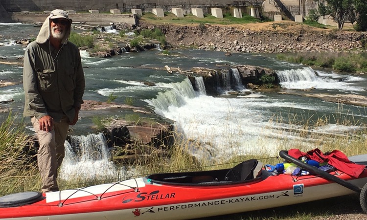
I recovered rapidly on the paved path. It was cooling down, the scenery was great and the pulling was easy. I even raced a laughing little kid on a bicycle for a way. Miles went by. I had someone take a photo of me at the beautiful falls at Black Eagle dam. Imagine what all these falls had looked like before the dams!
Black Eagle Falls
My next goal was the closest food, Taco Johns. At long last I was there.
“What’s the biggest combo you have?”
“Pardon me?”
“What’s the most food in any combo?”
“Number 8.”
“I’ll have Number 8.”
It was an wonderful feast. Plenty to eat and drink in air conditioned comfort.
Less than two more miles to go, wheeling down shady side streets. Many people joked about the unusual sight. I always enjoy seeing the old houses.
Here at last was my motel. It had been a 20 mile day pulling 100 pounds. I was tired.
The reception lady was yelling at a repair service on the phone. When she hung up she turned to me with a frown.
“I have a reservation. Bruce Nelson.”
“You didn’t say you had a kayak.” I hadn’t talked to her at all before.
“It’s OK. I can lock it up outside.”
“I’m not comfortable with that.”
“How about I put it in my room?”
“You can’t put it in your room!”
“I just pulled that boat 20 miles. It’s been a long day and I have reservations. What can we do here?”
“Sorry. I’m just out of my comfort zone.”
Of course, had I driven up with that same kayak, unlocked on top of a Subaru, there would have been no problem. The problem was in her head. Different is scary.
I found another place a few blocks away.
“Can I put my kayak in my room?”
“That will be fine.”
“Or how about I lock it to the fence here?”
“I don’t see why not.”
It was a much nicer place as well, for just a few $ more.
I went up to a snazzy room. For the first time in over two months I had a room that had everything: running water, WIFI and TV. After getting all cleaned up I went for a giant sub sandwich with all the veggies, then came back and did my laundry in the tub and watched the news on TV.
It had been two very big, adventurous days. I will really enjoy a full day in Great Falls tomorrow. Many errands and plenty of eating and rest. Colter
Clark: June the 15th Satturday 1805 a fair morning and worm, we Set out at the usial time and proceeded on with great dificuelty as the river is more rapid we can hear the falls this morning… the curt. excessively rapid and dificuelt to assend great numbers of dangerous places, and the fatigue which we have to encounter is incretiatable the men in the water from morning untill night hauling the Cord & boats walking on Sharp rocks and round Sliperery Stones which alternately cut their feet & throw them down, not with Standing all this dificuelty they go with greatchearfulness… the Indian woman much wors this evening, She will not take any medison, her husband petetions to return &c., river more rapid late in the evening we arrived at a rapid which appeared So bad that I did not think it prudent to attempt passing of it this evening…
Lewis: Thursday June 13th 1805… my ears were saluted with the agreeable sound of a fall of water and advancing a little further I saw the spray arrise above the plain like a collumn of smoke which would frequently dispear again in an instant… I hurryed down the hill which was about 200 feet high and difficult of access, to gaze on this sublimely grand specticle. I took my position on the top of some rocks about 20 feet high opposite the center of the falls. this chain of rocks appear once to have formed a part of those over which the waters tumbled, but in the course of time has been seperatedfrom it to the distance of 150 yards lying prarrallel to it and forming a butment against which the water after falling over the precipice beats with great fury; the whole body of water passes with incredible swiftness. immediately at the cascade the river is about 300 yds. wide; about ninty or a hundred yards of this next the Lard. bluff is a smoth even sheet of water falling over a precipice of at least eighty feet, the remaining part of about 200 yards on my right formes the grandest sight I ever beheld…
Clark: June 22nd Satturday 1805… they are obliged to halt [while portaging] and rest frequently for a few minutes, at every halt these poor fellows tumble down and are so much fortiegued that many of them are asleep in an instant; in short their fatiegues are incredible; some are limping from the soreness of their feet, others faint and unable to stand for a few minutes, with heat and fatiegue, yet no one complains, all go with cheerfullness.
Trip overview and route map with position updates: