Headwaters of the Missouri

July 28, Day 127, Mile 2321
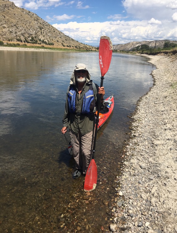
Today was a landmark day, the day I reached the headwaters of the Missouri and the end of my long journey upstream along this longest river in America.
In the morning I was on my last map page of “The Complete Paddler,” the guidebook nearly all Missouri Paddlers carry.
Like many prior days, fast stretches of current alternating with paddleable water had me crawling in and out of the boat many times.
Mink romped along the shore occasionally, swimming across the river as the mood struck them. One stick floating down the river turned out to be a young mink, who suddenly dove on my approach. Blue herons waded the waters and two sandhill cranes fed in the grass. Three big whitetail bucks walked a gravel bar into the willows.
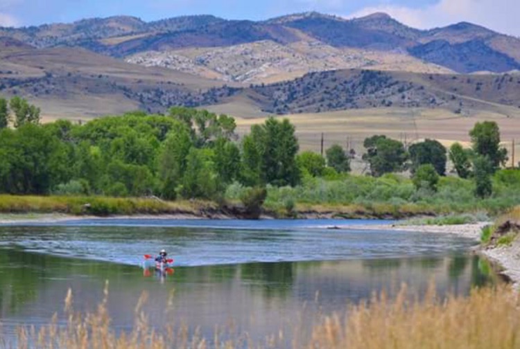
The remaining miles counted down: 12, 8, 3. Limestone cliffs towered over the river.
Ahead I could see a lone person with a black lab. That would be my smokejumper buddy Jim Griffin. I lifted my paddle in triumph and he raised his arms with a yell.
“How does it feel?” He said.
“It feels great!”
I wanted to paddle up a little farther, to the the confluence of the Madison, so Griff drove upriver.
Another person sat on a rock outcropping ahead. I knew that would be Norman Miller. He congratulated me on completing my long journey up the Missouri, pointing out the final landing just past a stand of cottonwoods ahead.
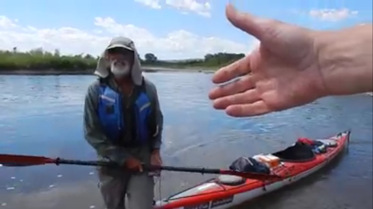
For one last stretch I pulled and paddled until Griff and Norman stood on the shore.
I pulled the kayak the last few feet and my upstream kayak trip was over, I was here at Three Forks. There were handshakes and congratulations.
Norm had brought me an usually good sub sandwich, and a tub of berries and fruit. He also brought a Budweiser beer, in honor of St. Louis where the Missouri runs into the Mississippi.
We got my kayak strapped onto Griff’s pick up and all my gear loaded up and we bid farewell to Norm. Thanks to Norm for all the support and all the good food and in sharing the adventure.
Griffin drove us to his beautiful mountain home near Whitehall, our base for many other expeditions. Griff made us a fine meal of elk steaks and salad and potatoes. As we ate outside a small bird landed on the railing eyeing the potatoes. It was so tame it allowed me to touch it before it flew away.
If you can access the Facebook “Missouri River Paddlers” group Norman Miller has posted photos and video of my finish.
I will likely spend two days here in Whitehall to rest, repair and resupply, then I will continue on the route over Lemhi Pass and onto Orofino where I plan to relaunch after about 500 miles and a month of hiking. The final segment will be 500 more miles to the Pacific. Colter
Lewis: Saturday July 27th 1805. We set out at an early hour and proceeded on but slowly the current still so rapid that the men are in a continual state of their utmost exertion to get on, and they begin to weaken fast from this continual state of violent exertion. at the distance of 13/ 4 miles the river was again closely hemned in by high Clifts of a solid limestone rock… we arrived at 9 A.M. at the junction of the S. E. fork of the Missouri and the country opens suddonly to extensive and beatifull plains and meadows which appear to be surrounded in every direction with distant and lofty mountains; supposing this to be the three forks of the Missouri I halted the party on the Lard. shore for breakfast… Capt. Clark… would rejoin me at this place provided he did not fall in with any fresh sighn of Indians, in which case he intended to pursue untill he over took them calculating on my taking the S. W. fork, which I most certainly prefer as it’s direction is much more promising than any other. beleiving this to be an essential point in the geography of this western part of the Continent I determined to remain at all events untill I obtained the necessary data for fixing it’s latitude Longitude…
Lewis: Sunday July 28th 1805… we called the S. W. fork, that which we meant to ascend, Jefferson’s River in honor of Thomas Jefferson. the Middle fork we called Madison’s River in honor of James Madison, and the S. E. Fork we called Gallitin’s River in honor of Albert Gallitin… Our present camp is precisely on the spot that the Snake Indians were encamped at the time the Minnetares of the Knife R. first came in sight of them five years since. from hence they retreated about three miles up Jeffersons river and concealed themselves in the woods, the Minnetares pursued, attacked them, killed 4 men 4 women a number of boys, and mad prisoners of all the females and four boys, Sah-cah-gar-we-ah or Indian woman was one of the female prisoners taken at that time; tho I cannot discover that she shews any immotion of sorrow in recollecting this event, or of joy in being again restored to her native country…
Trip overview and route map with position updates:
https://bucktrack.com/Lewis_and_Clark_Trail.html
Congratulations, Buck! Have you got any preconceived ideas about how long it will be before you start paddling again?
Thank you Allen. I’m guessing a month but I’m not sure how long it will take to get my trail legs back.
Buck
Congratulations on arriving in Three Forks! You’ve been making some excellent daily mileage above Fort Peck Reservoir despite the generally faster water. I know how tough it is to paddle upstream in this section of the river, and am very impressed. I have a few thoughts about your next hiking section:
1. The roughest terrain which the Lewis and Clark expedition crossed on their trip was the section over Lost Trail Pass. It isn’t clear what exact route the expedition followed over the pass. However, an article in the June 28 Missoulian explained that the Lewis and Clark Trail Heritage Foundation, the National Smokejumper’s Association, and the USFS believe that they have deduced the route that the expedition took while descending from the pass towards the Bitterroot Valley, and the USFS intends to make some trail improvements along the route in August. The route runs down a ridge to the west of the highway and north of Lost Trail ski area and ends at Lost Trail Hot Springs. If you hike down the highway, you’ll be able to look across the canyon at that ridge. To get a map and other information about this route and the new trail, contact Deb Gale at the USFS West Fork Ranger Station, 406-821-3269. Or if you send me your e-mail address, I’ll forward you an-mail from Deb which contains this information. The USFS’s topo map of the trail doesn’t show Lost Trail Ski Area, which is located on the west side of Lost Trail Pass on both the north and south sides of the divide.
2. While the fastest route north from Lost Trail Pass is to simply follow Highway 93, if you want a quieter hike, you could follow the Gibbons Pass road, which diverges from Highway 93 at the pass, runs generally parallel to the highway to the east, and joins the highway at Sula, where Lewis and Clark met the Salish Tribe in Ross Hole. It’s a few miles longer than the highway because it does more zig-zagging through draws, but you might not get passed by any vehicles at all on this road. If you hike the Gibbons Pass road, I suggest that you cut over to Highway 93 on a side road a couple of miles before Sula.
3. In the Bitterroot Valley, there aren’t any secondary roads which parallel Highway 93 for any distance except the Eastside Highway, which runs between Hamilton and Florence. The Eastside Highway is almost as busy as Highway 93, and much of it has narrow shoulders. A nice bike path runs along the west side of Highway 93 from south of Hamilton to Lolo. The simplest way to get to Lolo is by hiking the bike path.
4. The Bitterroot Valley is fairly developed, but contains wooded areas where you could sneak off and do some bandito camping. There are also fishing access sites along the river a mile or so to the east, and some USFS campgrounds at the base of the Bitterroot Mountains several miles to the west.
5. I live in Missoula, and hope to be able to meet you someplace in the Lolo area. If you need to do any shopping in Missoula, I’d be glad to drive you around.
6. In Lolo, check out the Travelers Rest State Park, where Lewis and Clark camped for several days going both west and east. Researchers were able to identify Lewis and Clark’s latrine by using scientific equipment to locate mercury deposits underground in poop from members of the expedition. The mercury was from pills which Lewis and Clark gave members of the expedition in an effort to cure almost any malady, which made them poop like crazy. And since Lewis and Clark set up their camps in accordance with instructions in a contemporary military manual, historians have been able to deduce where the camp must have been located with respect to the latrine. The park is a day use only area, but if you want to ask them to make an exception and let you cam there, contact Park Manager Loren Flynn at 273-4253.
7. Once you get about 12 miles west of Lolo, the land is almost all owned by the USFS, and there are several USFS campgrounds and endless opportunities for bandito camping. There is a nice Lewis and Clark interpretive center at Lolo Pass.
8. There are essentially no services between Lolo and wherever you hit civilization in the Orofino area. Don’t count on buying anything other than chips, pop, and an ice cream sandwich at Powell (Lochsa Lodge), which is about 15 miles west of Lolo Pass. But a bigger problem is that there is very little water available along the Lolo Motorway. You’ll need to carry a lot of water, and you may need to hike several miles down off the ridge to get water in sections of the Motorway. I have a friend in Missoula who has done a huge number of solo backcountry motorcycle, hiking, and fishing trips in Idaho, and has done several trips along the Lolo Motorway, the latest one this week. He can provide you with information about sources of water along the ridge. If you e-mail me, I’ll send you his contact information.
Hi Peter,
That’s a lot of good info, thanks for taking the time to post it. I am going to email you so you can send the info from Deb. Sorry this is so brief. I’ll be rereading your info.
Thanks again!
Buk