

Below are updates of my trip. Words in italics are the updates written by Melanie (see the FAQ page) that I called in by satellite phone. The other text, and photos, I wrote before I left (June 14 and June 15) or added after my return.
June 14: I have my all my packing done except for a few small details. There’s still a long list of “ to do” before I leave, but things are going well. Currently, the plan is to fly out with Marty on Saturday, June 17, or as soon as possible after that date.
June 15: I went into the smokejumper base and talked to Marty and the boys today. Marty has done lots of good planning. If he can get time off, he or his brother will fly a fuel cache N. of Ft. Yukon on Sunday, and Marty will fly me out on Monday, June 19. We’ll drop the Wind River, Marsh Fork and Sheenjek caches on the way in, and then he’ll drop me at Joe creek. Marty will fuel up using the fuel cache after dropping me off. He may camp the first night at Joe creek if it’s getting late.
I weighed my pack for the first leg and it weighs about 43 pounds including food and a quart of water.
June 17: Hello everyone, it’s Melanie, and I’ll be doing the updates to Buck’s website this summer while he is hiking. He will be calling me occasionally on his sat phone to let me know his location and how things are going, and I will post that info on the website. It looks like tomorrow is the day. Marty flew out some fuel caches today and then tomorrow will fly Buck out to start his trip. In a way, all the getting ready is the really hard part, and the fun for Buck will start when he stands alone at Joe Creek, watching Marty fly away.
June 18: Buck left this morning at 8:00 to start his trip. Because of easterly winds today, Marty will probably drop Buck off at the Joe Creek spot and then fly on to place the food caches, getting GPS coordinates of the drops. Buck plans on taking it easy this evening, and tomorrow hiking to the Canada border for the “official” start of the trip.
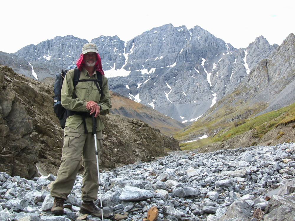
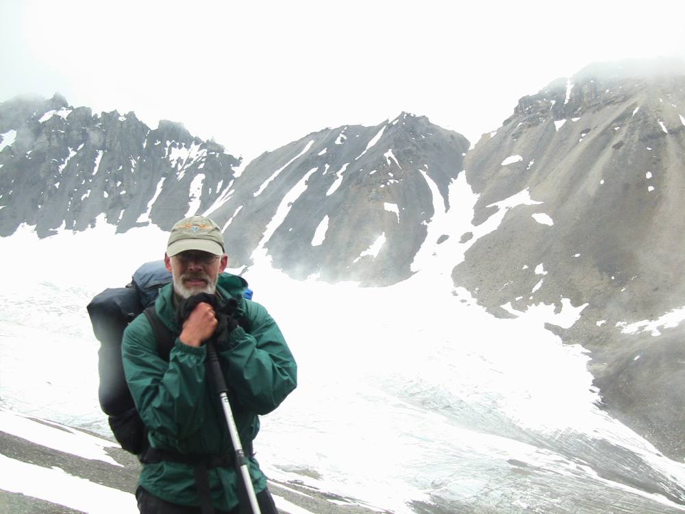
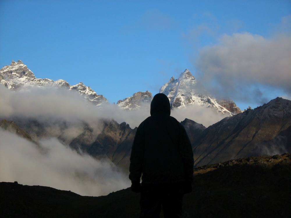
This photo shows me with Marty Meierotto’s (Yes, the guy from Mountain Men!) Super Cub on day one at Joe Creek, about 10 Miles from the Yukon border. This was one of the nicest days in the first two months of the trip! No skeets, a light pleasant breeze on a warm sunny day.
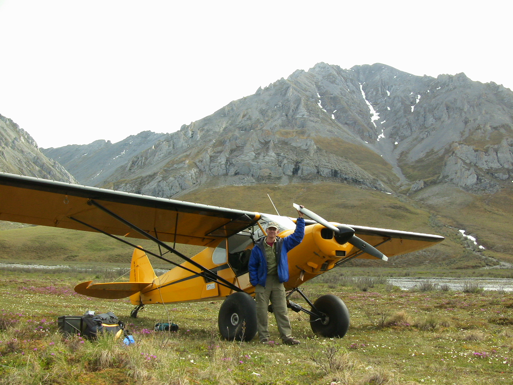
Drop-off point at Joe Creek, Arctic National Wildlife Refuge
Photo taken June 18
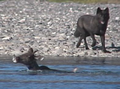
June 21: Buck called tonight on his sat phone, and over a very bad connection and getting cut off about 3 times, I got some news. He is at 68.57, 141.58. When Marty was flying him out, they found 3 pieces, about 18” long each, of mammoth ivory on a gravel bar in the Porcupine River. He’s walking about 15 miles a day, which comes out to covering about 10 miles on the map, so he is right on schedule. It’s been raining a lot, and the stream crossings have already been too numerous to count. The coolest thing that’s happened so far was seeing a big white wolf. Buck saw him trotting off, and ran after the wolf to get another glimspe, only to have the wolf stop and sit on the ridge above Buck and howl and howl and howl at him. We only spoke about a total of 3 or 4 minutes, but during that time he said “I just saw a caribou go by”. The scenery is beautiful and the walking is good, and despite the rain and multiple stream crossings, all is well.
This is a piece of mammoth tusk I found on a gravel bar of the Porcupine River on our flight out. As we were landing, I looked at the eroding bank along the river and said to Marty, “Do you want me to let you know if I see a mammoth tusk?” In an incredible coincidence, a few minutes later I was walking across the gravel bar and found this piece! Finding tusks and pieces is rare, but by no means unheard of in Alaska. No, I didn’t keep it.
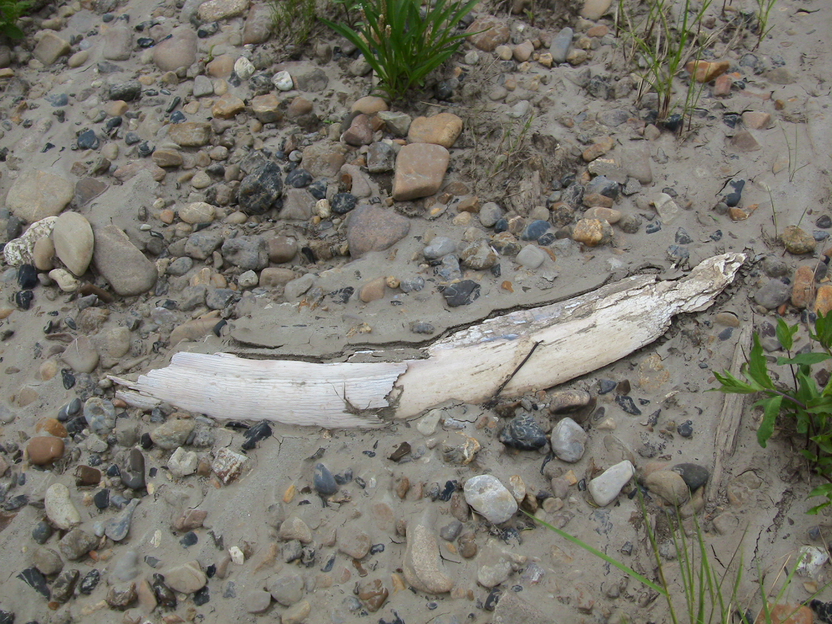
Mammoth Tusk, Porcupine River, Alaska
Photo taken June 18
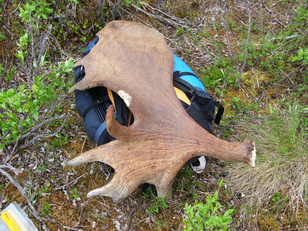
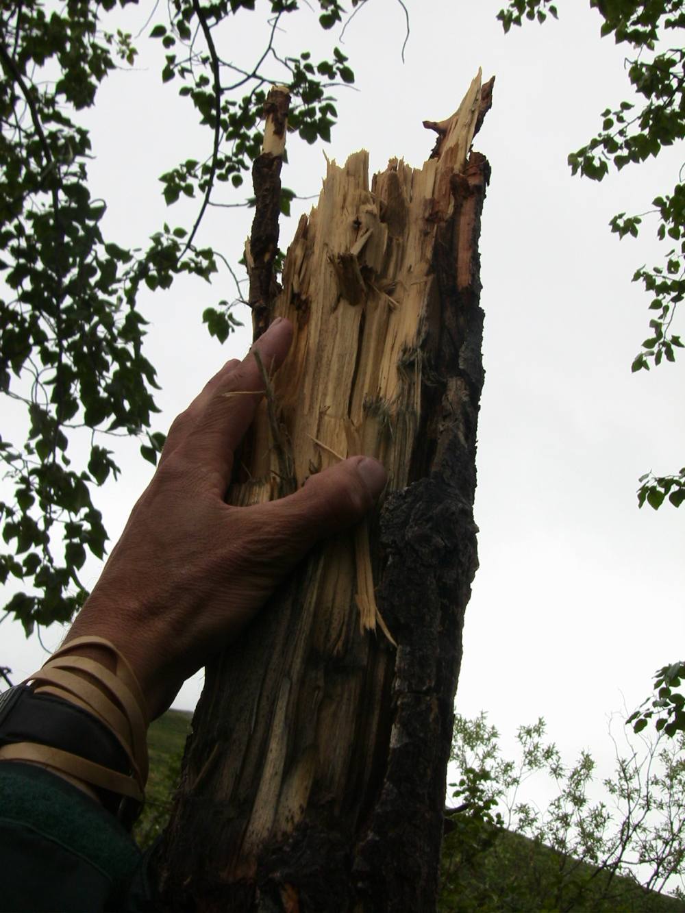
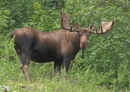
I found hundreds of shed antlers in the Brooks Range. Here’s a photo of a shed moose antler shown against the backdrop of the mountains along Joe Creek.

A huge moose antler next to my pack!
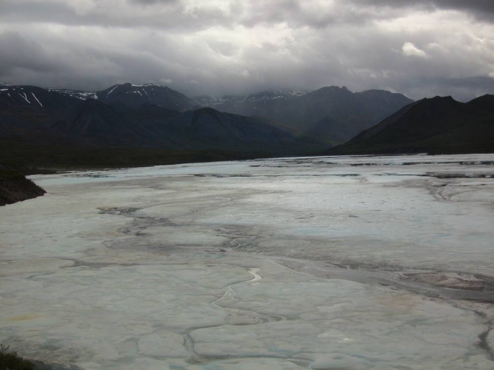
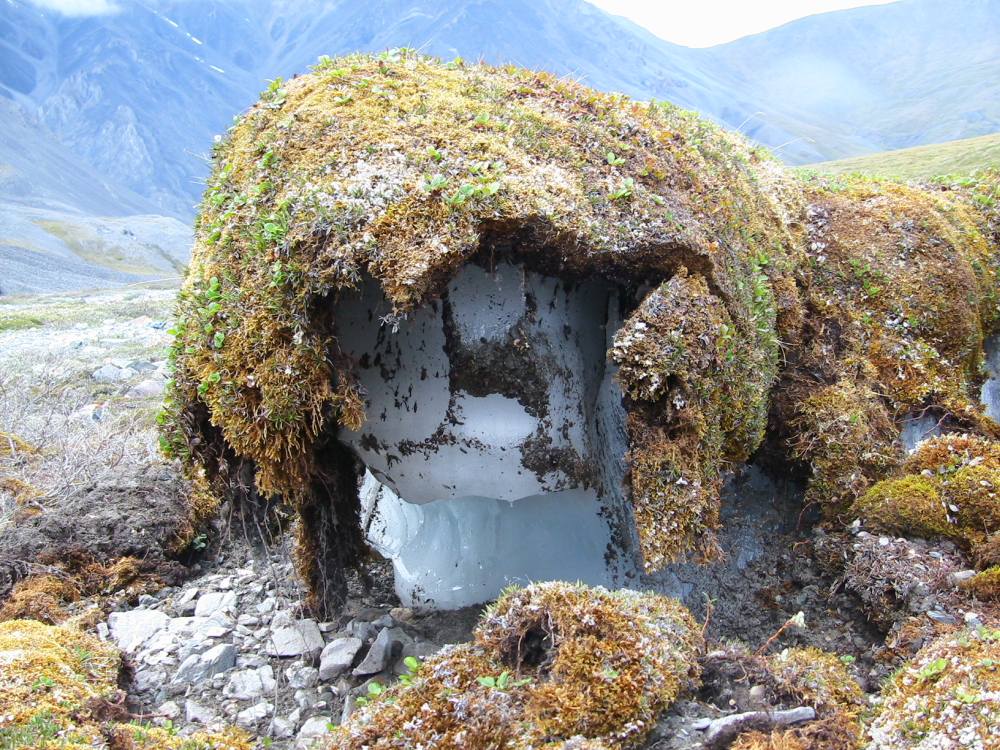
Aufeis is a German word meaning “ on top” and is the remaining “” ice from the previous winter. Basically, it is formed when a stream is partially blocked by ice and water upstream runs out on top of the ice, slowly building up the aufeis. I saw very thick aufeis here at Joe Creek (at least 10′ thick in places), and on the Kongakut River, the Sheenjek, the Marsh Fork of the Canning, and many other rivers. The headwaters of these streams were “” in late June because of all the ice.

Aufeis, Arctic National Wildlife Refuge
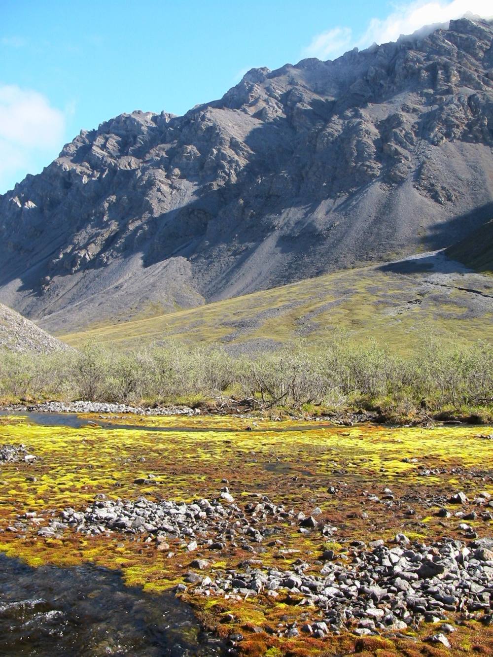
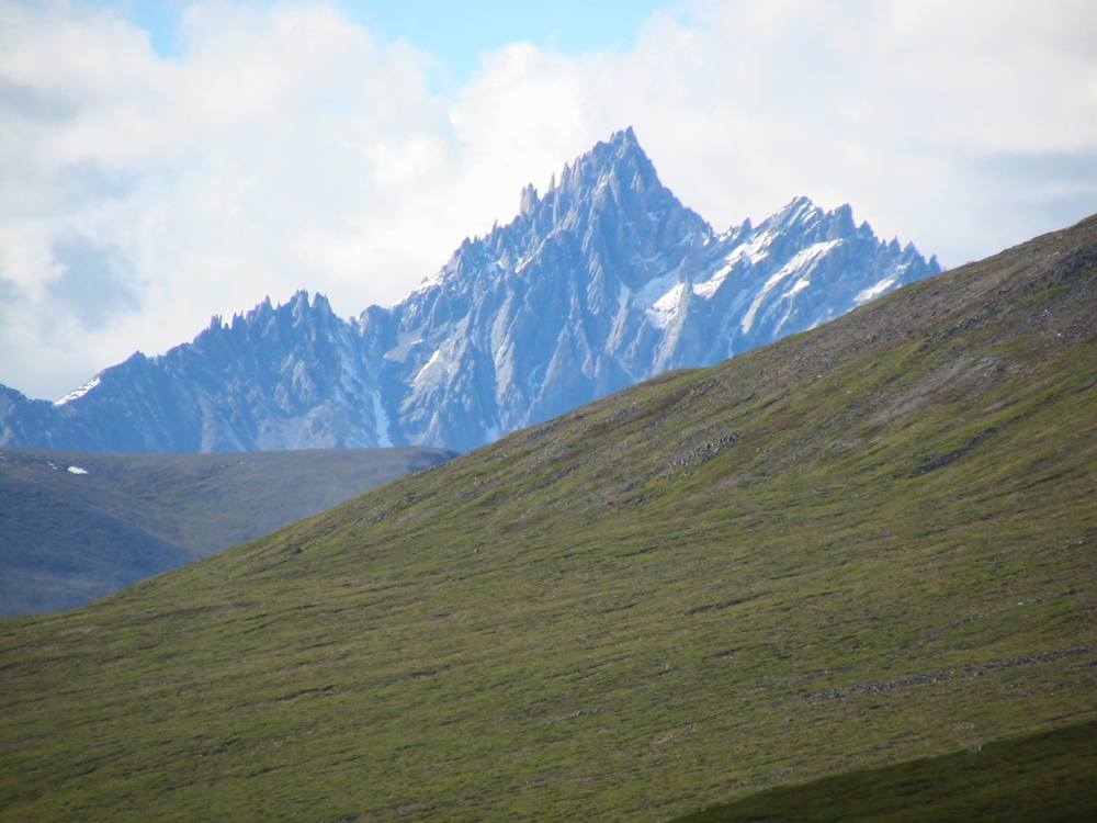
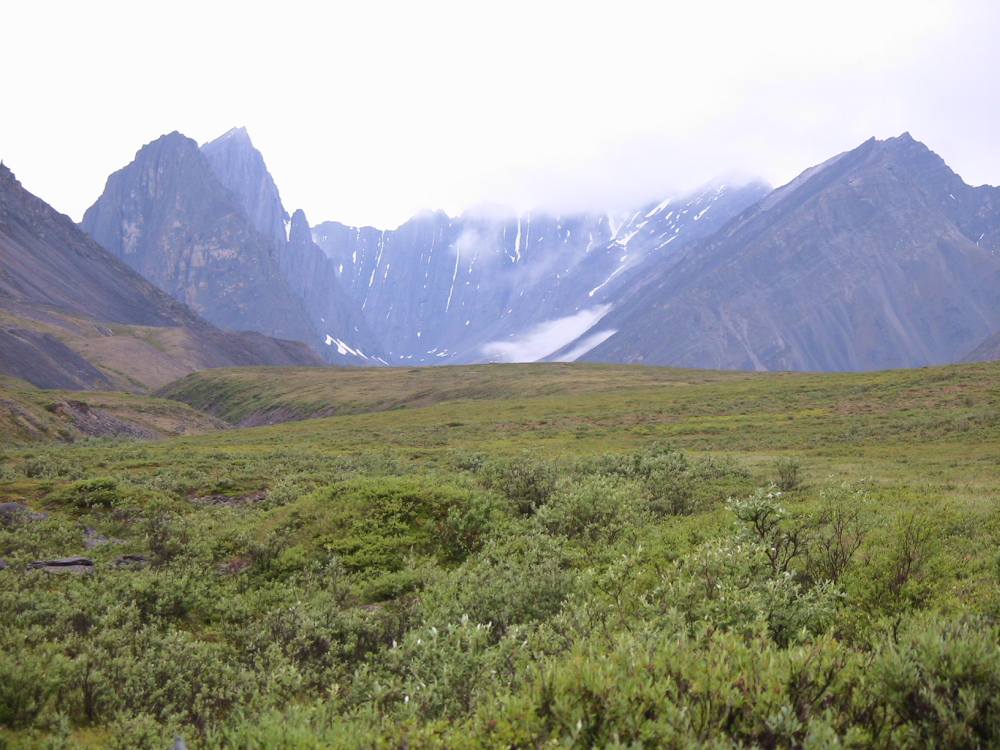
Joe Creek was a beautiful, remote spot, over 200 miles as the crow flies from the nearest road (the Dalton Highway.) The walking was easy in this stretch. There was an unusual line of ridges partway down the mountains, barely visible in the photo, that reminded me of the plates on the back of a stegosaurus. This area, and for about the first few weeks of my trip I was hiking in the Arctic National Wildlife Refuge (ANWR.)
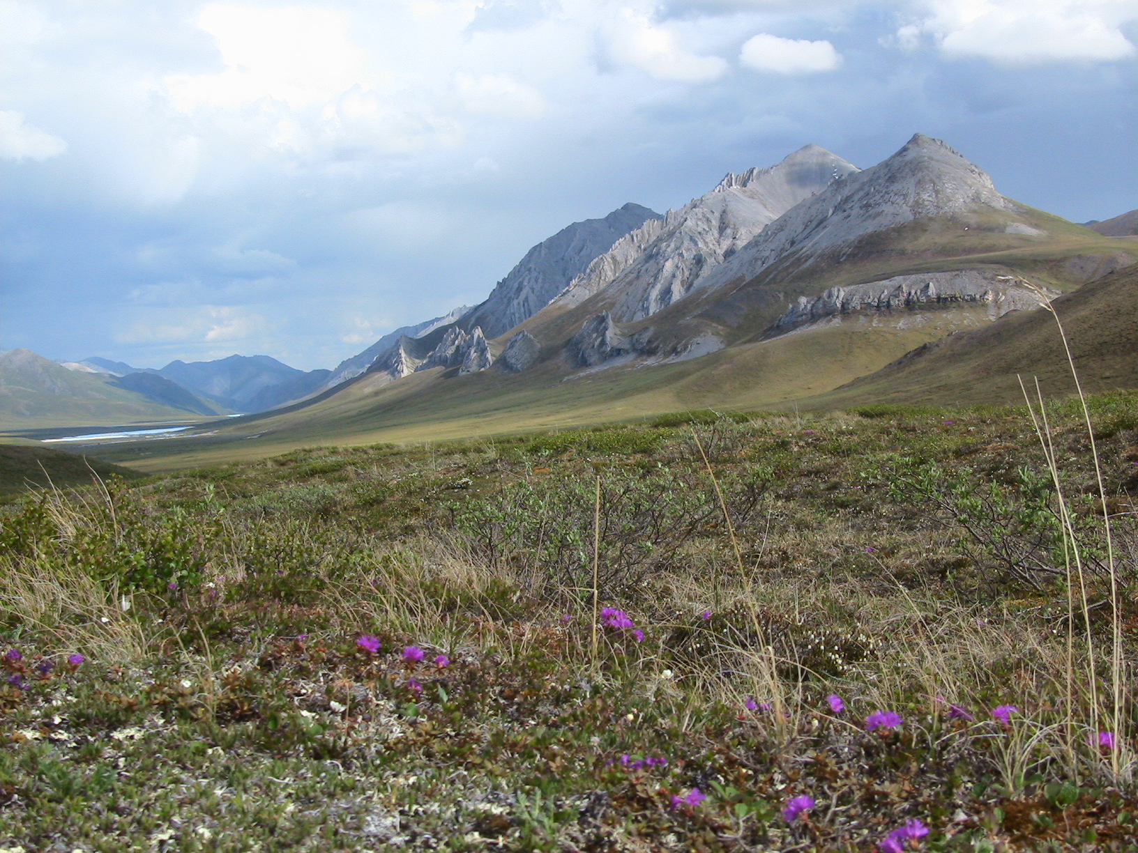
Typical scenery, north slope, eastern Brooks Range
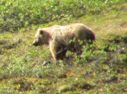
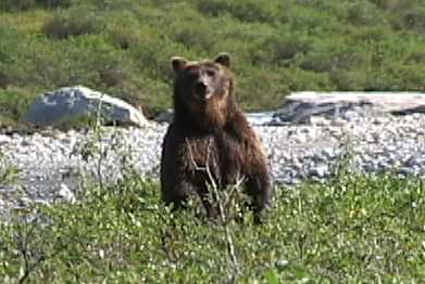
This is a fuzzy photo, but things were happening fast and I was switching from video to photos and I was trying to get a shot before the bear disappeared into the brush. This grizzly spotted me from a distance, and rapidly approached on the opposite side of the creek. When he crossed the creek and headed for the brush, I knew he was still thinking I was a potential prey animal. I started talking to him and opened up my raincoat and spread it out to make myself look bigger. As he got closer and smelled me, he whirled and ran straight up the mountain!
Grizzly headed my way!
Photo taken June 21
Flowers were common and came in many species and colors. I saw new varieties for much of my trip with the changing seasons and at different altitudes and locations. There’s at least three species in this photo. I believe the small white flowers (in the lower bottom of the photo, for example) are Bell Heather. The bluish flowers are Lupines. Anyone know what the other variety is?
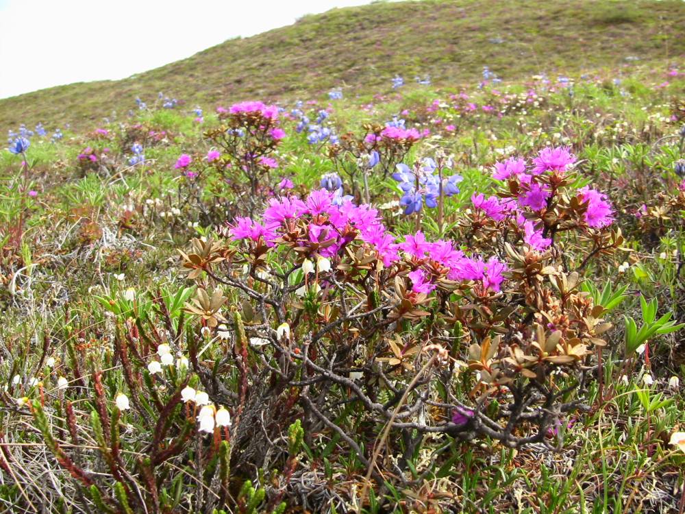
Alaska Wildflowers
Photo taken June 21
There was a vast amount of aufeis on the upper Kongakut, even in late June. Summer is fleeting in the arctic! Often walking on the aufeis was much easier than walking along the river. I tried to stay away from the running water as much as possible. In general, the main water channels melted first.
River Aufeis
Photo taken June 22
Here is another unusually large shed moose antler I found the first week. Notice how big it is compared to my pack!
Giant bull moose antler
Northern shrikes were fairly common birds in the Brooks Range. They scolded me when I got near a nest or young. Shrikes kill many small birds and rodents. Three times during the summer I saw shrikes carrying mice.
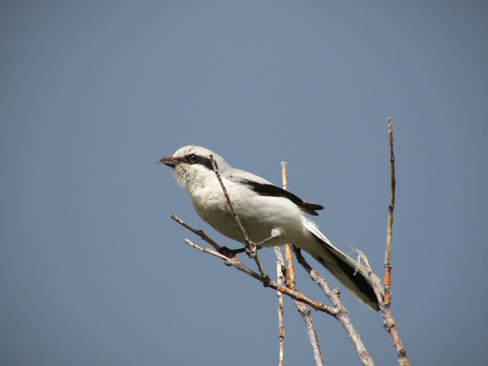
Northern shrike
I wish I knew more about rocks, because there were many interesting specimens to be seen. A friend of Melanie’s has tentatively identified this stone as banded chert. I had thought it was agate.

Banded chert, I believe
Photo taken June 21
June 27: 68.48, 143.59. Yesterday Buck crossed the Continental Divide, leaving the Sheenjek River drainage. He’s now walking up the drainage to the East Fork of the Chandalar River, which is territory he covered in his 2000 hunt when he filmed “700 Miles Alone”. He commented on how much he recognizes from that trip, including the grayling pool which he filmed for the video, and will probably catch a few more grayling out of there for dinner. Buck hasn’t seen any sheep or moose in the last couple days, though continues to come across dozens and dozens of moose antlers. He also hasn’t seen any people. A couple of days ago he saw 2 more grizzlies, and later on some ptarmigan chicks with their mom. Last few days Buck’s been doing 13 miles a day, walking from approximately 8:00 am to 6:00 pm, though that varies. The rivers have lots of “aufeis” (a fun Google word), some of which appears to have been there for several seasons without melting. Tomorrow will be more familiar territory from the 2000 trip, and he’s enjoying seeing these places again.
June 29: A message from Buck on my answering machine when I got home from work: “I’m at 68.56, 144.32. I crossed the Continental Divide today at Guilbeau Pass, things are going great. Every view is a calendar, it’s all beautiful. I found a set of moose antlers that I’d found on my 2000 hunt. I saw nine sheep today, no people, and no footprints.” Buck’s hiking in ANWR right now where he’s seeing no sign of people anywhere. I work for the BLM permitting the oil and gas development in Wyoming, and this has given me some insight into how much the character of ANWR will change if it is opened for oil exploration.
There are lichens on most undisturbed surface rocks in Alaska, and they come in unexpectedly bright colors, such as bright orange and yellow as shown below. Other common colors are white, black and green.
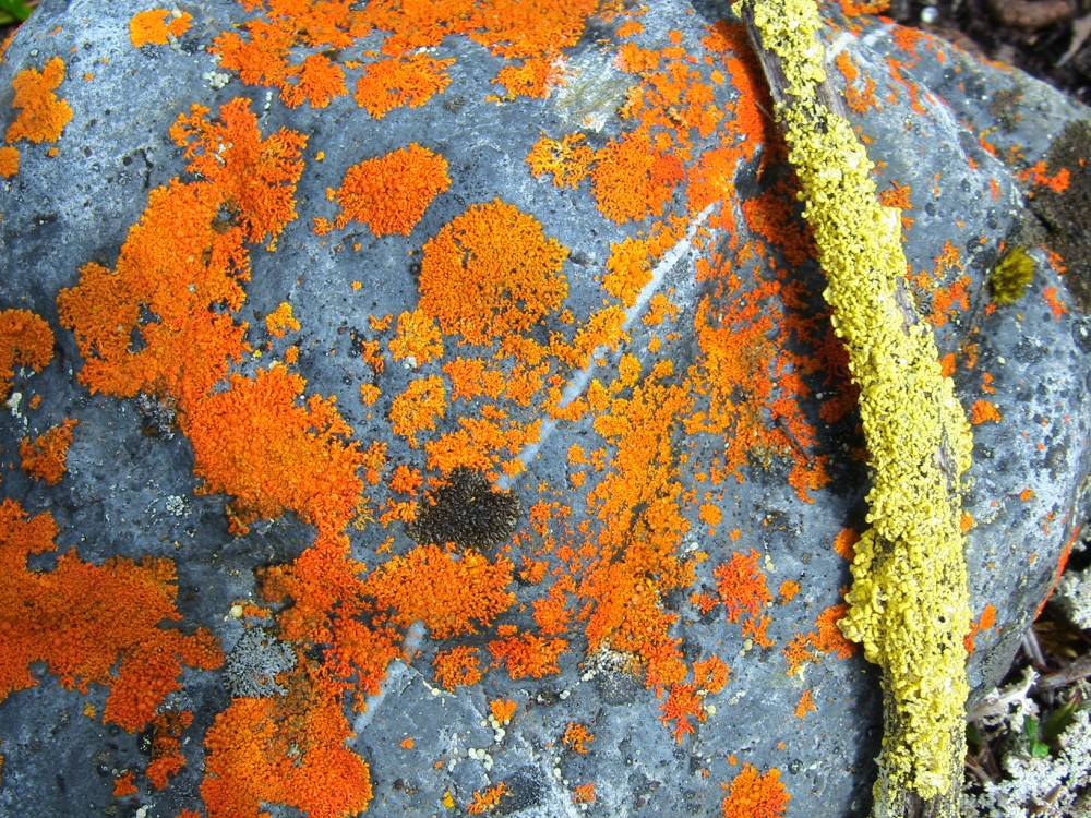
Orange and Yellow Lichens
Photo taken June 27
Mosses also vary in color. There are the standard greens, but also mosses that are nearly orange or yellow, as some of this moss growing along a small stream in a tributary of the Sheenjek River.
Sheenjek Tributary
Photo taken June 28
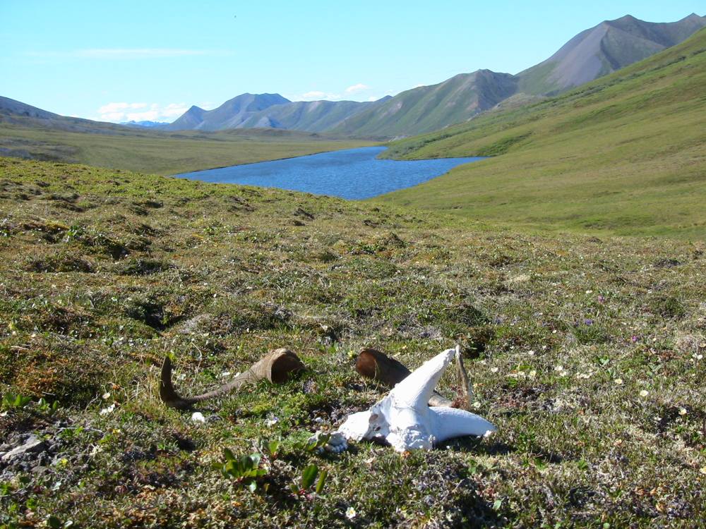
Antlers and bones last a long, long time in the arctic if animals don’t chew on them. I found this same skull six years before when passing through the area. It was old the first time I found it, and had suffered very little weathering during those six years.
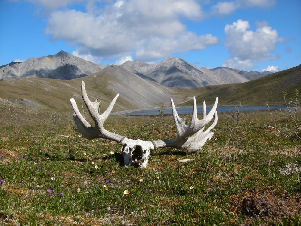
Alaska Bull Moose Skull and Antlers
Photo taken June 28
June 30: Buck crossed 2 passes today, and is going to be sleeping by the Canning River tonight. He was on a hunt on the Marsh Fork of the Canning in 1985, and he is looking forward to seeing that same spot again, 20 years later. Animals today included a nice big bull moose, and a bull caribou, along with a little band of sheep. He had fun watching the little lambs skittering across the hillside, bouncing along ahead of the ewes. It rained all day and was quite cool, but he said things “went well” despite this, so by that I’m assuming he stayed dry and comfortable. The drawback to the overcast weather, though, is that it makes it tough to use the solar charger to recharge batteries for his camera and sat phone.
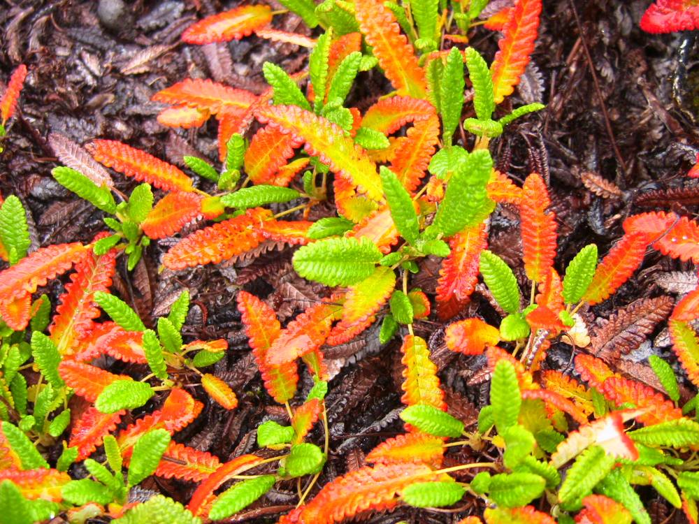
Tundra Flowers and Lichen
Photo taken June 29
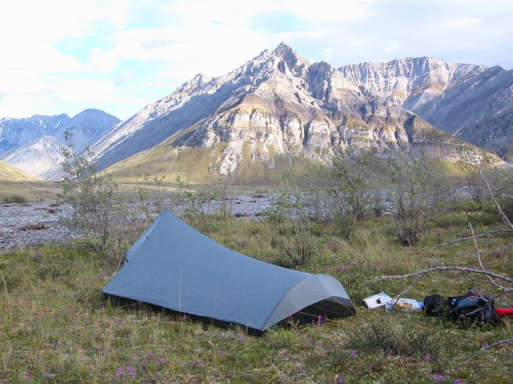
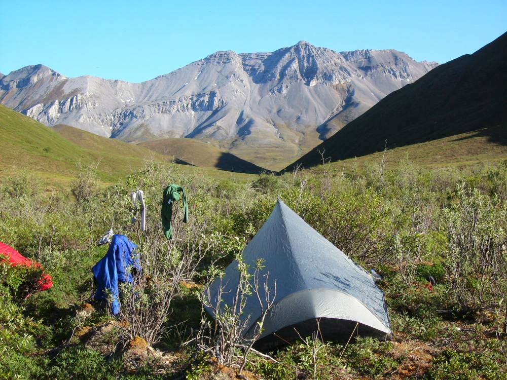
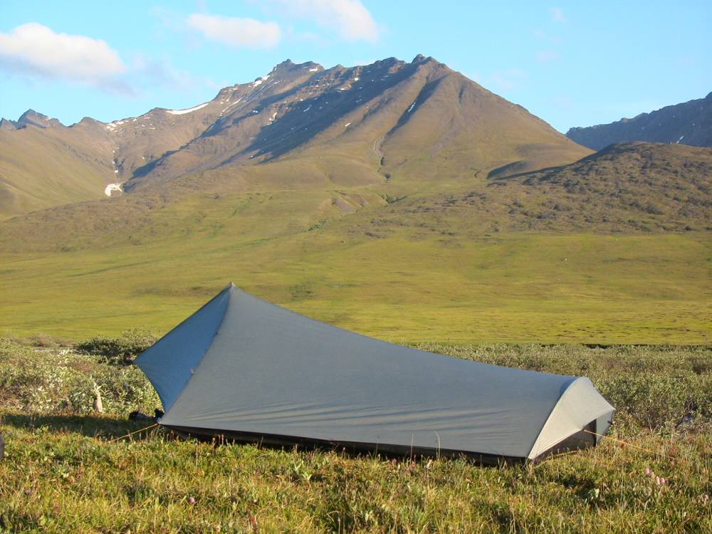
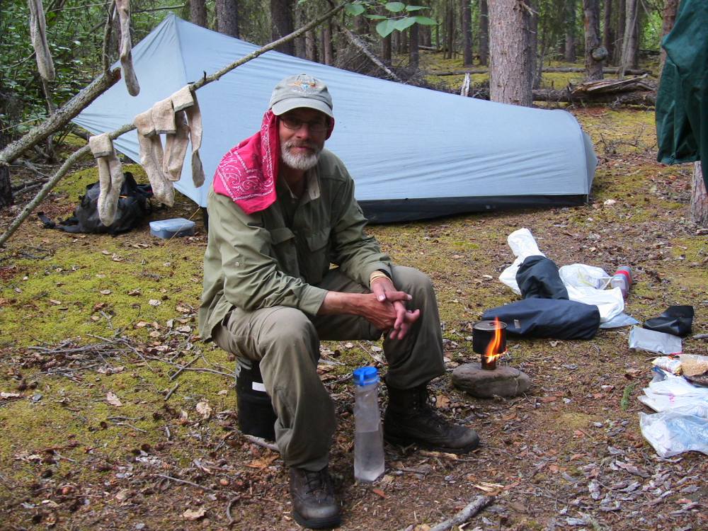
I used a Henry Shire’s Tarptent on this trip. Single-walled, with bug netting and a waterproof floor, it weighs 2 lbs or a bit less! I slept dry and (once I’d killed any skeets that had sneaked in during setup) bug free. I’d take a photo of each camp. I’d usually start looking for a campspot around 6 PM, although I’d sometimes quit early if a rainstorm was looming, or occasionally I’d hike as late as 9 PM.

Mountainside camp, Brooks Range
Photo taken June 29
One evening just before camping I saw a Dall ram high on the mountainside. I climbed part way up for a better look, then descended to find a camp. As I was preparing dinner a couple hours later, I looked up to see he had fed his way down the mountain and was just above my camp! (this photo out of order to protect the true location!)

Dall sheep ram
You are rarely far from ice when hiking in the Brooks Range. Of course, most of the year there’s snow and ice on the ground, but even in the summer there’s is usually permafrost beneath your feet. I thought this was an interesting formation. Underground ice was melting, leaving a layer of tundra draped over the remaining ice.
Arctic tundra moss over melting permafrost
Photo taken June 29
July 2: I actually spoke with Buck today, over a connection that lasted more than 30 seconds. He’s at 68.58, 145.30, having covered 172 miles so far. He is walking about 30% more than he had anticipated having to walk, but is keeping on schedule in spite of the extra walking. The last three days have been cold and rainy, and it even snowed a bit this morning. The cold is keeping the bugs pretty much out of the picture, though the few times there have been crazy numbers of mosquitos, long sleeves, pants, and bug dope pretty much do the trick. All of the rain has the rivers up quite a bit, so Buck has to do some re-routing and hike further upstream for crossings than he had planned. He continues to see sheep here and there, with the odd caribou thrown in, though most of the caribou herd is further north. The other night he was finishing up a hard climb down off a pass, when he saw a grizzly sow with her two cubs, feeding up the hill towards him. This was a very large bear for the Brooks Range, a “very nice dark color”. The cubs were bouncing around, enjoying themselves, when Mom caught wind of Buck. She went up on her hind legs for a moment, then turned and ran and ran and ran, making her poor little cubs scramble to keep up. Buck said it was just like the time in his video, when that sow ran her cubs up over a big ridge, and he imagined them thinking: “Wait! We can’t go that fast!”.
July 5: Another phone message today: 68.43, 146.08. Buck is at his cache on the Marsh Fork of the Canning River, having walked over 200 miles so far. The other day he got some good video of a big boar grizzly feeding on hillside opposite him, and the bear never even knew Buck was there. Buck also got a fairly close-up view of a big gray wolf yesterday, and all week long he has continued to see sheep. He also saw some rafters on the Marsh Fork, which are the first people he’s seen other than distant rafters on the Kongakut River. The only glitch so far is that he has been having trouble with the battery charger for his video camera. Marty plans to fly in a replacement when he drops off the Wind River cache, so the hope is that a new charger will fix the problem. Buck didn’t mention whether the rain had stopped, but did say things are going well.
The most common mammal I saw on my trip was Arctic Ground Squirrels. The squirrels pictured were part of a colony of perhaps 2 dozen or more. The most interesting fact about ground squirrels is that their body temperature actually falls several degrees below freezing during the eight months they hibernate! Every three weeks or so they’ll slowly warm up to a normal temperature, never leaving the nest or waking up. After half a day of warmth, they’ll cool back down.
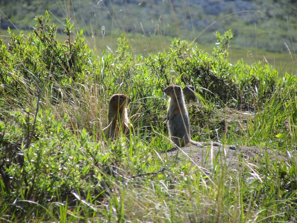
Arctic Ground Squirrels
Photo taken July 5
Tree-line was usually very distinct in a drainage. Here is the farthest north clump of trees on the Marsh Fork of the Canning River. Tree-line in the Brooks is around 2,200 feet, but north of these cottonwoods there are no trees regardless of altitude.
Marsh Fork, Canning River
Photo taken July 4
This is my camp on the Marsh Fork of the Canning River at about 11 PM on July 4. The sun didn’t set for the first month or so of my trip. It didn’it get fully dark for weeks after the first sunset, because the sun was barely below the horizon.
Riverside campsite
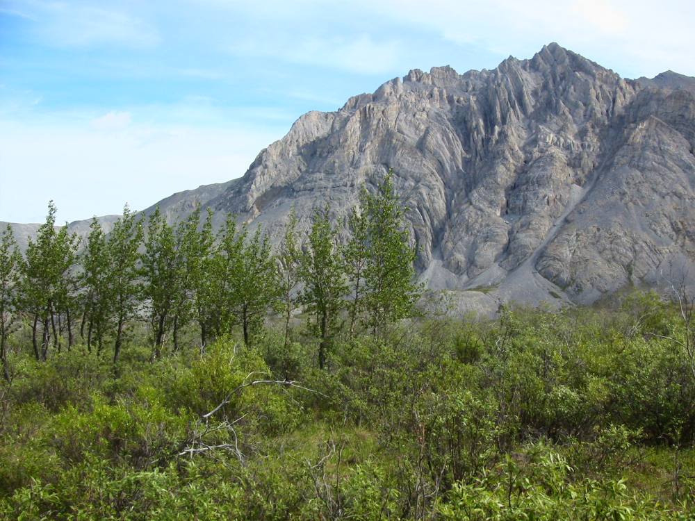
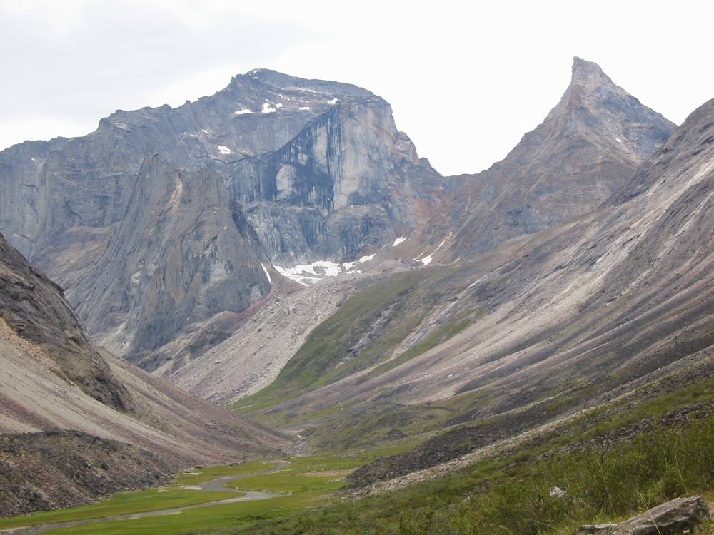
There are countless spectacular peaks in the Brooks Range that are unnamed. As far as I know, this is one of them. It was extremely rugged with dozens of sharp spires.
Rugged peak
Although grizzlies eat plenty of moose, caribou and other large animals whenever they get a good opportunity, most of their feeding time is spent on plants and berries. I watched this “blonde” grizzly feeding on vegetation on a mountain side for 45 minutes or so. Grizzlies have a very good sense of smell, and good hearing, but relatively poor eyesight. He never did see me.
Blonde Grizzly
Photo taken July 3
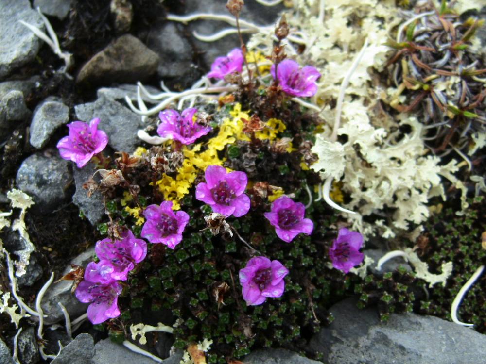
A close look at the tundra would often yield a look at a varied and colorful collection of wildflowers, lichen and stone. The white plant is a type of lichen. Lichens are actually a combination of algae and fungi, growing together in a symbiotic relationship. Does anyone know what type of flowers are in this photo? Email me at buck@bucktrack.com if you know. My whole trip until this point was in the Arctic National Wildlife Refuge (ANWR.)
By July 5, when this photo was taken, it had rained (from sprinkles to hard rain) 15 of 18 days. I’d also done a lot of creek and river crossings, too, so I’d take advantage of sun when I could. At this camp, I hung up all of my socks and clothing and anything else that was damp. I also set up my solar charger. By late evening, everything was nice and dry and my batteries (satellite phone, camera, and personal) were recharged. The sun shone on my tent until it went behind the mountains at midnight.
Drying damp gear
July 7: 68.47, 146.35. Buck had lots of cool finds to talk about in his latest report: a ram skull complete with horns, two arrow points, a scraper, a a bunch of flakes. He really gets a big charge out of finding artifacts like that, and thinking about the people that made them. He took photos, then left all the artifacts where he found them. Another high point was catching a char using his tent pole as a flyfishing rod; he said it worked pretty well, he could get lots of line out. He had lots of strikes, but only actually caught the one. The last 3 days have been sunny and nice, which has offset some really tough walking. He’s still covering lots of ground in spite of this, and plans to be at his Wind River cache site on Monday.
These wildflowers are Pink Plumes and Lupines.

Pink Plumes and Lupines
Photo taken July 5
At a good lookout point overlooking a valley I found hundreds of stone flakes from ancient toolmakers. I carefully looked around and soon found this arrowhead or possibly atlatl, point. I also found another point and what was likely a hide scraper. It is fun to think about who might have made these tools, and how many hundreds or thousands of years ago, and the animals, possibly extinct, they were hunting. I left all these artifacts for archaeologists and other hikers to find.
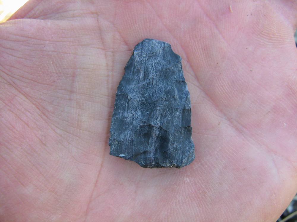
Projectile point
Ptarmigan were very common. This photo was taken in early July, when chicks were just barely starting to fly. At the approach of danger, their first defense depends on their mottled coloration to blend in. Usually, the mother ptarmigan pretends to be injured, trying to lead the predator away from the chicks.
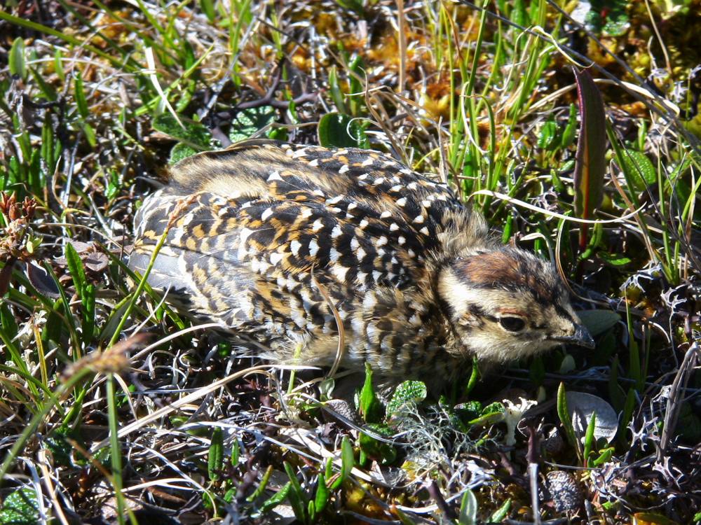
Ptarmigan Chick
Dall sheep ram horns grow throughout their life. Here is an old skull where the horns have fallen away from the horn cores of the skull. This ram was likely killed by predators as he was crossing this low valley.
Dall sheep ram, skull and horns
Photo taken July 5
July 8: Buck is at the headwaters of the Ivishak, 68.38, 147.02. Yesterday he walked almost 17 miles, which is really a tremendous day in trackless tundra country, and his longest so far. He mentioned that the walking the previous day had been terrible, but much better yesterday. The high point of the day happened when he was walking down a gravel bar, the sun a little lower in the sky, shining across the water. He looked up and saw a wolf, with a beautiful smoky gray/tan coat, come trotting towards him. Buck got out the video camera and was able to get some great footage as the wolf continued to come towards him, passing within 20 yards of him. The wolf didn’t really seem to know what Buck was, and continued trotting up onto a ridge, where he sat and watched Buck for several minutes. Finally the wolf got bored and trotted away. Buck also got some nice video of a little ptarmigan chick, tottering around near its mom. As far as the overall trip, Buck mentioned that it is going great but is also very challenging. Every day is an all day slog; wake up in the morning and walk, no matter what, and it is a lot of work. Of course, that is what makes it all so worthwhile. Buck also mentioned to me that if anyone wants to send him any snail mail, they can send it to:
Bruce L. Nelson
(Please hold for long distance hiker)
GENERAL DELIVERY
ANAKTUVUK PASS AK 99721-9999 .
He should be there in 3-4 weeks.
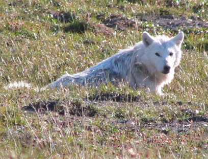
This was one of the most exciting encounters of the trip. I’d spotted this wolf trotting out of the willows downstream of me on a gravel bar of a creek. He didn’t see me at first. When he spotted me, he didn’t know what I was, and continued trotting my way staring intently at me. He got closer and closer. I was taking video the whole time. I took this photo just as he had crossed a channel of the creek. If you click on the image and look closely at the larger photo, you can see water dripping off him. A moment later he got spooked and trotted up the mountain side where he watched me for several minutes. The image at the top of the page is this wolf.

Wolf stare-down
Photo taken July 6
This is simply a beautiful spot on a beautiful day.

Creek-side wildflowers
Photo taken July 8
My goal for each day was 10 miles “as the crow flies.” That would usually work out to about 13 miles of actual walking on the ground, as I followed or crossed rivers, and detoured around major obstacles and the like. I’d take several breaks every day. Shown in this photo is the hiking pole I used. It was extremely useful for balance, and it prevented many falls in steep or uneven ground. And it was usually steep or uneven! It was especially useful for stream crossings.
Hiking up the Ivishak River
This plane wreck was a sad, dramatic sight. It was a twin-engine plane that flew into the mountainside just short of a pass. The wreckage was a time capsule of sorts. An old book still contained clearly legible citations for wildlife violations, written in the 50s. There were boots, canned food and singed clothing. The curled propellers showed the engines had been running when the plane hit. It was easy to imagine what had happened: the pilot flying up the narrowing valley and encountering low clouds so he couldn’t see ahead and with not enough room to turn around. He was only about 100 vertical feet from the top of the pass. Update: I was fascinated to learn the story of this wreckage from the folks at ANWR. In 1958, Clarence Rhode, director of the US Fish and Wildlife Service in Alaska, disappeared on a patrol flight along with his son Jack and Stanley Fredericksen, a game agent. Rhode was a widely respected man, and the largest search ever conducted in Alaska was launched. Up to 28 aircraft and 260 people were involved. The mystery of the disappearance of this Grumman Goose N-720 wasn’t solved until backpackers discovered the wreckage in 1979. You can see a photo of Mr. Rhode and this aircraft here.

Clarence Rhode’s Grumman Goose
I took this photo just as I began dropping down into the Wind River, where the headwaters of the Ivishak, Ribdon and Wind Rivers met. It is very easy to turn down the wrong valley if you’re not watching the map closely! I made one significant wrong turn on the trip, which resulted in about 10 hard miles of extra walking.

Headwaters, Wind River
Photo taken July 9
There was always something interesting to see, such as this interesting rock formation against the backdrop of the mountains.
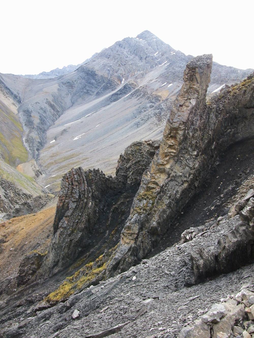
Rock formation, Brooks Range
Photo taken July 9
This photo was taken just before I crossed the Continental Divide between the Ivishak and Wind Rivers. I wore the red handkerchief on the back of my neck for much of the summer. It helped a lot to fend off mosquitoes and also as a sun shield.
North side, Eastern Brooks Range
Photo taken July 9
July 11: 68.18, 147.39 Today was another actual phone conversation, as opposed to the usual update on the answering machine. Buck is on a tributary of the Wind River tonight, and tomorrow will hike up over a pass and down into the middle fork of the Chandalar. He walked about 13 miles today, and mentioned finding an old horse stirrup that had obviously been around for many years. Buck has lost about 8 pounds, not because he doesn’t have enough to eat, but more because it’s tough to constantly be gobbling up so much rich food. He said that tonight, for example, it’s raining, and he’s not going to get out of his tent and cook up a bunch of rich food that he’s not in the mood to eat. “I’ve been eating all day, and if I wasn’t burning such a tremendous amount of calories I’d be as fat as a pig!” He feels good, though, and not weak or anything from the weight loss. The walking portion of the trip is almost half over, and once he gets on the river he can gain back what he lost.
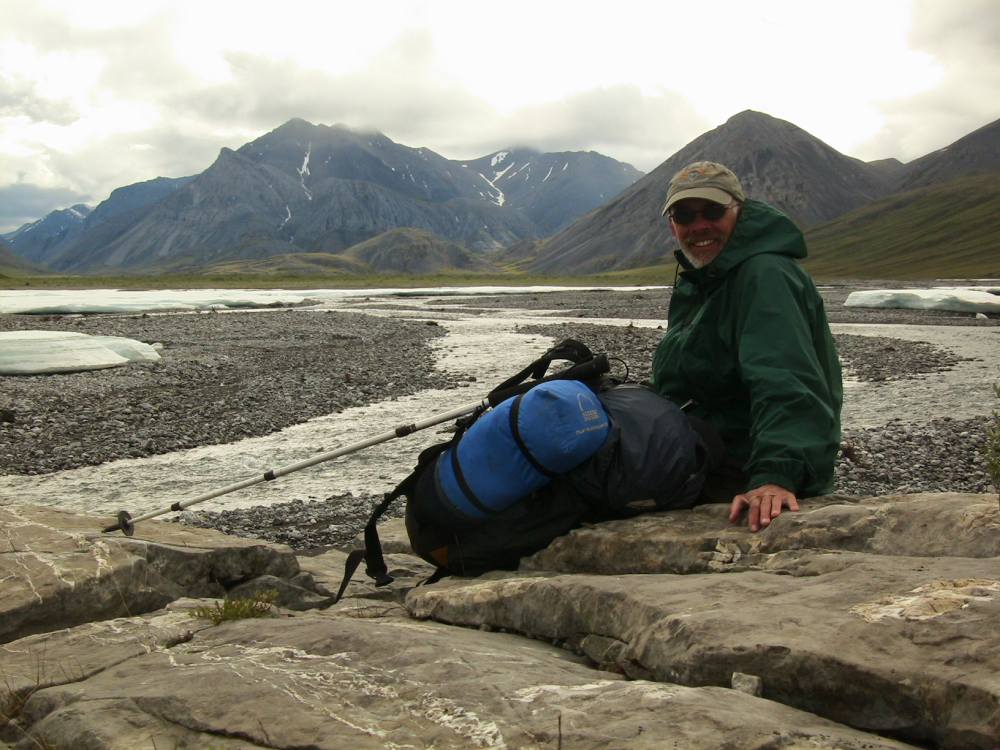
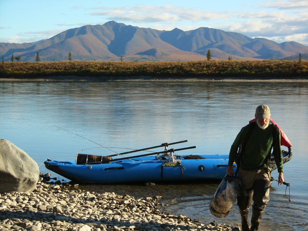
The day Marty flew me out, he wisely avoided dropping my Wind River cache due to bad weather. Instead, he flew up my cache shortly before my arrival. Little did I know, as I camped just upstream the evening before I arrived at this landing spot, that Marty was camped there with his plane! I was surprised to spot his bright yellow Super Cub through the willows as I arrived at Wind River. Marty was far away on a mountain side looking over the country with his binoculars, so I hung up a large white plastic bag so he could spot me easier. A dark rainstorm was headed my way, so I quickly sorted out all my trash to be flown out, and rummaged through my food cache to take the food I needed. Marty and I only had time for about fifteen minutes of visiting, then he had to fly away to avoid the bad weather!
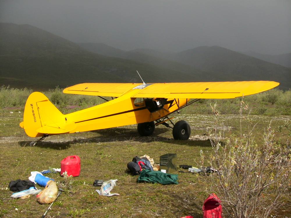
Marty Meierotto’s plan
Photo taken July 10
July 13: 68.16, 148.12 Buck has walked over 300 miles so far, and seen the tracks of only 2 people. Right now he is on the upper Middle Fork of the Chandalar river. He has been seeing a whole bunch of ptarmigan with their chicks, “just lots and lots of ’em!” He also sees wolf and caribou tracks all the time, though the main critter sightings the last couple days have been the ptarmigan. Buck did some more fishing yesterday with his tent pole and fly line, and caught several grayling. He mentioned that although it’s rained 23 out of 26 days, he’s also had sun for 24 of 26. It won’t be long now before he comes to the Dalton Highway, also called the Haul Road, the only road he will cross in hundreds of miles.
July 14: 68.09, 148.40 It was a cold, steady rain all day long today. Buck says he sleeps warm and comfortable at night, and is fine when he’s moving, but it’s tough to stop for any length of time in weather like that. I told him it’s been over 100 degrees here, and he laughed and said he could use a few of those extra degrees. At one point he was walking along through some willows, came around a corner, and surprised a wolf that was just wandering along towards him. They both jumped, and the wolf turned and ran, looking over his shoulder at Buck, so much like my dog Jack when he is startled that Buck said he was tempted to call out to the wolf, something reassuring like “’s okay!”.
July 17: A very short update today. Buck arrived at the Haul Road today, amidst more rain, and even some snow. He told me that it’s been so cloudy that using his solar charger for his phone battery has been difficult, and with that piece of info we lost the connection. He did say before that that he is doing well and is happy about how things are going. I’d say he has reason to be happy; I’m looking at my map, and it’s a long way from the Canada border to the Haul Road…
This photo shows me climbing a snow field in the headwaters of Your Creek. I crossed many passes during my trip.

Another pass
Photo taken July 15
One morning when I looked out of my tent five rams were feeding nearby. I got some good videos of this band, including rams fighting. (this photo out of order to protect the true location.)
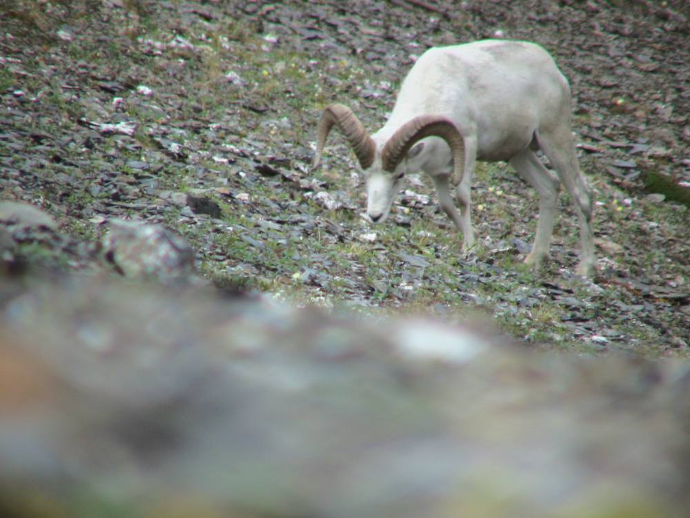
Dall sheep ram
July 18: Tonight’s call was the worst connection we’ve had yet, so again my information is very limited. I got about a sentence at a time, and then lost the connection. Buck got to the Haul Road and got his cache okay. He said today was his toughest day yet, and started to explain why, beginning with “the rivers and creeks are just getting higher and higher”, but then got cut off. He did call back to say he was making it fine, and safely. Another break, then he told me he saw a grizzly that was as light a color as he’s ever seen. He also saw a little black bear. He is getting rained on a whole lot, which may explain the bad connection-hard to solar charge your battery when the sun doesn’t come out. He’s okay though, and looking to take a day off here in the next couple days, the first in over a month.
On the 30th day of my hike I reached the Haul Road, a major milestone of the trip. I’d walked about 364 miles. A nice friend of a friend named Janice had stashed a “bear cannister” full of food for me just off the road. As I happily sorted through all the goodies, I looked up to see a large “white” animal on the hillside. It turned out to be a very “blonde” grizzly.
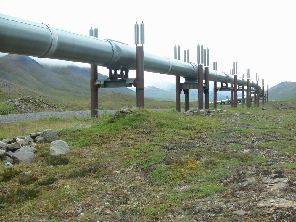
Alaska Pipeline near Atigun Pass
Photo taken July 17
July 20: 68.06, 150.17. Yesterday Buck took a day off. This trip is proving one of the most physically demanding things he’s ever done, so it was really nice to just rest in the tent after many long hard days. While he was lying there in the tent he heard a small scuffling, followed by the appearance of little brown legs as a curious arctic ground squirrel stalked up to his tent and peered in. Buck said something like “Hi there little guy!” and off the squirrel went. He got some sun, too, and was able to get things dried out and batteries charged up and good things like that. Today he came over Oolah Pass, and is in sight of the Itkillik River, which he plans to walk down tomorrow. At this point he is probably about 6 days out from Anaktuvuk Pass.
July 23: 68.07, 150.53. Buck is at a waterfall at the headwaters of the Anaktuvuk River, in Gates of the Arctic National Park. A big band of sheep is up on the hillside, watching his progress. Today he also saw two moose and two grizzlies. The second bear was sitting happily in the middle of a patch of apparently yummy vegetation, munching away. While Buck watched, the bear sort of scooted around on his butt, getting better situated so he could enjoy his snack. Buck noted that the fall colors are already starting to come in, while there is still some of last year’s ice clinging to several lakes. Last night he camped at the foot of a glacier, on the North side of the Continental Divide again. Today he has been hiking in a broad, open valley, and said that the walking has really been good today, with the last three miles being the best so far. The rain has persisted, however, falling up to twelve hours a day. The gortex on his boots failed a ways back, so the last couple weeks he has been walking with wet feet. He does have replacements waiting for him at Anaktuvuk Pass, so that is fortunate. While we were talking he spotted a second band of sheep up on the hillside. He also mentioned finding lots of fossils lately, of various plants and other unidentifiable things. Only a couple more days to Anaktuvuk Pass; he will probably get there about Tuesday.
Near this spot I found countless fossils in the rocks near a ridgetop. After reaching the crest, I looked down to see this glacier. I nicknamed this drainage “the Valley of the Bones” for all the fossils and the much more recent caribou bones and antlers.
Crossing the Divide
The weather the day before had been cloudy and rainy, so I was delighted when I woke up in the morning and this beautiful mountain was out. Good thing I got up early, because the clouds were soon “on the deck” again! This photo was taken in Gates of the Arctic National Park, which I entered about five miles off the Haul Road.
Cocked Hat Mountain
Photo taken July 22
The walking was relatively good along the Anaktuvuk River. It got tougher near the village of Anaktuvuk Pass, where I stopped to pick up mail and supplies.
Tarptent at Anaktuvuk Pass
Anaktuvuk Pass has been a major caribou migration corridor throughout recorded history, and likely well back into prehistory. In that area there were hundreds of sets of caribou skulls and antlers from local Nunamiut (eskimo) hunters. The mountains in the background overlook the village of Anaktuvuk Pass.

Caribou antler, Anaktuvuk Pass
Photo taken July 24
July 27: 67.59, 152.08. Today Buck is powered by home made chocolate chip cookies from Mom Nelson. He is hiking along the John river, enjoying good walking after a day of horrible walking yesterday. The sun is also out about half the time, which, combined with the cookies, has made for a cheery kind of day. Buck spent some time watching a porcupine enjoying some willow leaves, pulling them one after the other into its mouth. Later, Buck saw a distant moose, or possibly a caribou, galloping along the river bank. At one point just before he stopped for lunch, Buck was coming up on a thick patch of willows, whistling to alert any bears that might be hanging around, when a big brown animal came crashing out of the stand. Fortunately, it was a moose, running away from Buck, but it was still pretty exciting. Then a little bit after that a 4-engine airplane flew over, just 200-300 feet off the deck, “looking just like a retardant ship on final before dropping retardant”. It was probably just some guys flying cargo out of Anaktuvuk Pass, having fun flying low, but it was certainly a surprise. This evening Buck was about a mile and a half from a grizzly on a hill side, and could see the bear shining in the sun as he moved. The blueberries have started to ripen, so that will be a nice change of diet, and the salmon berries aren’t far behind. It hasn’t gotten dark at night yet on this trip, but will probably get dark for the first time in the next couple weeks.
July 28: 67.53, 152.32. Friday afternoon, Buck is at Walkaround Creek. He had just had hours of slogging through horrible tussocks: “It just went on and on and on…”. He was hoping for a respite, however, for he had just made the edge of some spruce trees, and was planning on a little more walking before he camped for the night in the trees. He had just seen a wolverine not too long before. It was up on its hind legs, looking at him, and from that angle appeared at first to be a golden eagle, sitting on a kill of some kind. But then the wolverine dropped to all fours and scuttled off. Once that day, while Buck was making his way down a valley towards the river, he spotted a grizzly making its way down the other side of the valley, towards the same river. As Buck got closer, he got low enough to lose his view of the bear. Assuming the bear was in the same willows he was heading for, Buck started whistling and making noise, but didn’t spot the bear. “I was sure he was there somewhere, so I kept on making noise.” Finally, Buck did see the animal, who had been slinking away down the river, glancing around nervously. The bear had been frightened of Buck and trying to get away!
July 29: Buck is near Kutuk Creek. It’s quite a windy day, with some sun. He saw a family of wolves today, the white father sitting up on a hill about 600 yards away, and the mother out with her 3 fuzzy pups. The pups were busy playing, but mom seemed to detect that something wasn’t right. She called the pups to come to her, but they apparently got confused, and scampered closer to Buck! He had the camera ready and got some good footage of them before they realized they had made a mistake, and then they hurried off towards mom. Buck has also seen several moose lately. So far on this trip, he as walked about 500 miles; the walking portion of the trip is coming to an end soon. He should be floating the Noatak in a couple weeks if all goes well.
One day I ended up in the middle of a wolf pack! One wolf was on a nearby hillside, howling at me. Another watched from a nearby ridge. Suddenly, there were wolves howling all around me. When things started quieting down, I spotted two wolf puppies. I saw them briefly from about 30 feet away, then they trotted up the hillside. They began howling, too! This is shot of one leaping up the hillside. As I was leaving I saw a third puppy and could hear all three of them howling together.

Leaping Wolf Puppy
August 1: 67.34, 153.34. The Alatna River, below Arrigetch Peaks. It was a beautiful sunny day today, and Buck had a great view of the peaks this morning. Last night was a hard freeze-August 1st and summer is waning fast. Buck had a grizzly almost wander into camp last night: he heard a large animal go crashing away from camp, and this morning found grizzly bear tracks near camp. Buck also had another great wolf sighting today. He spotted the wolf, maybe 300 yards away in a draw, just as the wolf laid his head down. Buck did a sneak and got as close as he dared, then looked up to see the wolf fast asleep, “laid out like a wolf-skin rug”. After a bit Buck howled at the wolf, which made the animal raise his head, and they made eye contact. Finally the wolf decided he’d better move, but just like a sleepy dog he sort of drug himself up slowly and trotted off only a few yards before throwing himself down again. Eventually he seemed to wake up enough to decide that maybe he should get a bit farther away from this person, and trotted off.
I had just reached the top of a long ridge when I saw a white object a few hundred yards away. When I looked back it was gone, and I realized it must be a wolf. I dropped back behind the ridge, and sneaked up on him. He was sleeping so soundly that I was able to get as close as I dared. He was sleeping flat on the ground, and I finally had to “howl” to get him to raise his head. This shot is just as we made eye contact. It was 10 PM.
White wolf, Gates of the Arctic
Most times when hiking along a river in Alaska, and you’re just reaching tree-line, you’ll see where bears have made territorial markings on trees. Trees may be rubbed with hair sticking to the bark, or clawed, or bitten. In this shot I’m reaching as high as I can showing a cottonwood tree that has been bitten completely off by a grizzly! The top, still with leaves on, was nearby on the ground. (Those are spare rubber bands on my wrist. I used two rubber bands on each pant leg to seal them around my boot tops. I also used them for my rain pants and many other purposes.)
Tree bit off by a grizzly!
Photo taken July 31
The first ripe blueberries showed up in late July. They were a great addition to my diet, and bears fed on them voraciously.
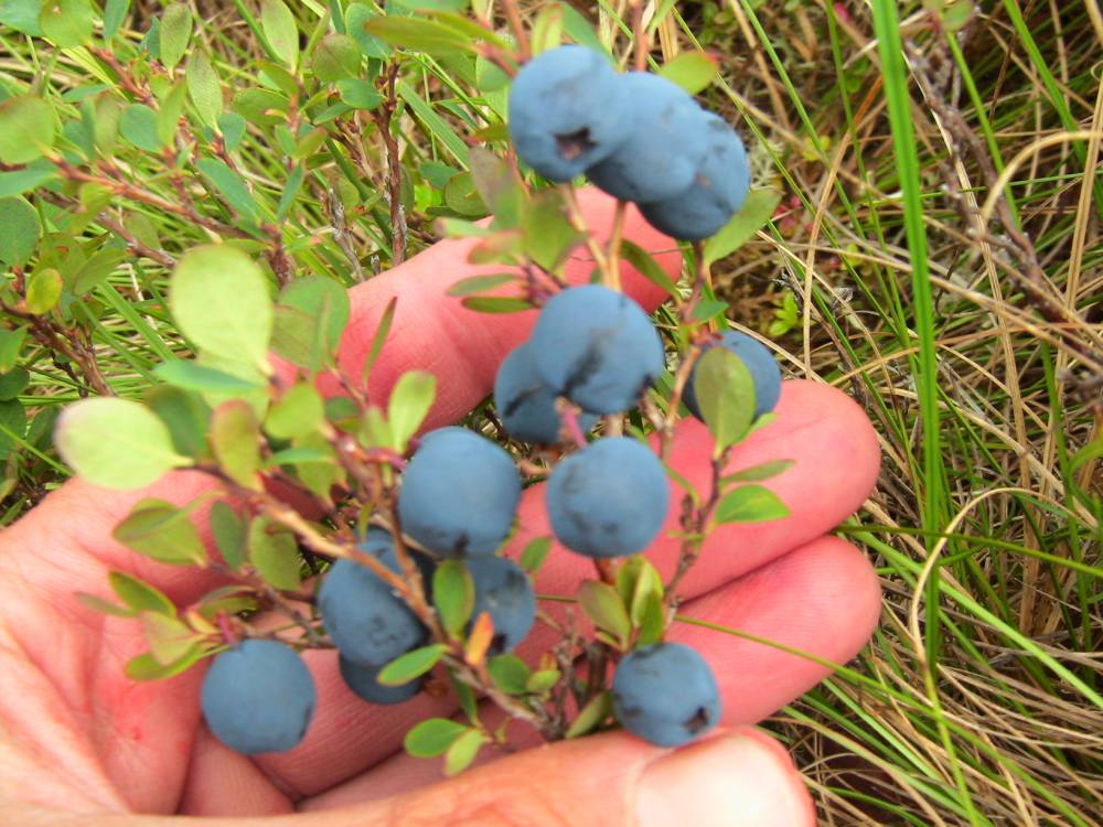
Ripe blueberries
Photo taken July 31
August 3: Buck is camped by Arrigetch Creek. He crossed the Alatna River, which was flowing swift and deep, by building a raft with a few poles tied together. At first he tried to use a long pole to pole across, but the river was too deep immediately, so instead he used sort of an improvised paddle. It all went perfectly, and he saved himself many miles of walking by crossing where he did and not having to hike upstream. The sun is out now and Buck has a perfect view of the dramatic Arrigetch Peaks, so that couldn’t have worked out any better, weather-wise. He also has a great camp spot-complete with view. Hiking yesterday he ran into a really nice couple, some folks out hiking in the park with their teenage sons. They were really interested in Buck’s trip, and really understood what was involved. Buck quite enjoyed meeting them. He had a little trouble finding his cache yesterday; it turned out to be about 0.2 mile from the coordinates he had, and so he had to hunt for it a bit, but found it eventually. He said that with the nice sunny day he is all dried out with batteries all charged up for only the second time the whole trip!
When I reached the Alatna River after walking down Pingaluk Creek, I found a deep and wide river. I estimated it would to take a day of walking to find a fordable spot upstream. So that evening I began floating some dry (dead) logs to the mouth of Pingaluk Creek. Combining a little parachute cord with drawstring cords, shoelaces and a bit of wire I had picked up, I made this crude raft. The two crossed poles on top are my long “push pole” and my shorter “paddle.” I zipped my sleeping pad into my raincoat as a life jacket, then launched into the swift current. Almost immediately, the water became too deep for my push pole, so I switched to my paddle. The river split into three channels and I paddled to the westernmost one. It wasn’t long before I was a half-mile downstream and safely on this gravel bar. I scattered the logs to “leave no trace.”

Crossing the Alatna on a raft
Most of my trip was above tree-line, so it was always a treat to camp in a nice stand of spruce, like this one near the mouth of Arrigetch creek. This photo shows my socks drying, my collapsible water canteen between my feet, and my tiny alcohol stove. The yellow flame shows I’m burning rubbing alcohol. Denatured alcohol and Heet are slightly better fuels, and burn with a clear flame. Arrigetch Peaks is probably the most popular area to visit in Gates of the Arctic National Park, but other campers in the area had done a great job of picking up all trash and “leaving no trace.” The walking was surpringly difficult in this area with only a faint “trail” in certain spots.
Camping in the trees!
Photo taken August 2
August 6: 67.23, 154.36. Buck has been hiking up Arrigetch Creek, and yesterday climbed over a very tough pass at the head of it, all the while with spectacular views. It did rain extremely hard yesterday, but then this morning was clear and sunny and beautiful and he got all dried out and batteries charged, in time to see and photograph a huge bull moose. The sun really makes a difference and he’s really been enjoying that, and has been taking lots of pictures of the dramatic mountains that surround him.
One of the most tense experiences of my trip was climbing this pass at the head of Arrigetch Creek. I climbed to the “saddle” just to the left of the sharp peak. When a light rain started and it became even more slippery, and I didn’t know if the opposite side of the ridge would be passable, it was a somewhat uncomfortable feeling. I was trying to be very conservative becauses falls in steep country are a greater hazard than grizzly bears in my opinion. Imagine my relief and euphoria when I reached the knife-edged ridgetop and saw an easy route down the other side!
Headwaters of Arrigetch Creek
Photo taken August 4
I didn’t see nearly as many moose as I expected. I did, however, see this big old bull. Quite a contrast in size compared to the weasel!
Bull moose, Gates of the Arctic
Photo taken August 5
The fall colors started showing up in late July.
August tundra, Gates of the Arctic
Photo taken August 5
This little weasel watched me (in between popping in and out of holes in the rocks) for about five minutes. Judging by his big feet, I would guess he’s a young weasel.
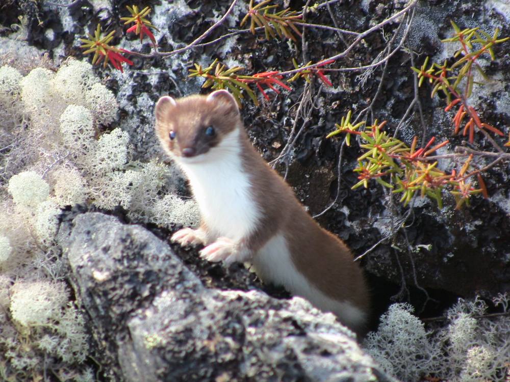
Curious Weasel
Photo taken August 6
August 8: 67.30, 154.51. Buck has crossed the last pass of the trip and is now in the Noatak river drainage. Tomorrow he will reach his raft, with another food cache-weight no longer an issue-and his rifle. He has walked 600 miles so far. Yesterday it rained for a full 24 hours, and he got completely soaked, but managed to dry out today. He also had several great bear sightings today, including 3 cubs with a sow, and a boar that decided to cool off in the river. The cubs were having “a great battle, with lots of sprinting and biting and little feet kicking up in the air.” Mom was busy eating blueberries as fast as she could, and whenever she would move off far enough that the cubs lost sight of her there would be a mad sprint to find her, followed by more playing. The cubs were also eating lots of blueberries, of course, sitting back and pulling the bushes towards them to get all the berries off. Later, Buck saw a boar come wandering up to the creek, so Buck had to cross to the other side to stay clear. This gave him a view of the bear, walking out into the middle of this very cold glacial stream and plopping down comfortably in the water. The bear kind of flopped around a bit, enjoying the water, then sat on his rear and reached his hind foot up to scratch behind an ear. Then the bear spotted Buck, and immediately came hurrying towards him. Buck got some very dramatic video of this, standing his ground while this big bear heading straight for him. The bear stopped though: It stood up on its hind legs and sniffed, realized Buck was not a moose or a caribou, and turned and hurried away. Buck has had this happen several times before, where the bear gets all excited, until it realizes it’s running at a person, and then turns and runs away. A familiar experience, but still a pretty exciting one.
This was the most tense bear encounter of the trip. I had seen this big bear across the river, and watched as he crossed to my side, stopping along the way to enjoy a nice swim in the cold water. When he disappeared into the brush on my side, I crossed the river and got out into the open. When he reappeared he spotted me, stood up on his hind legs, and began hurrying my way. I stood up on a big rock and hollered at him. He got closer and closer, standing up on his hind legs three more times. Finally when he could smell me he whirled and ran.
Standing grizzly
Photo taken August 8
At 8,570 feet Mt. Igikpak is the tallest mountain in that area of the Brooks Range. This shot was taken early in the morning when the top of the mountain emerged from the clouds.
Mount Igikpak, Schwatka Mountains, Brooks Range, Alaska
The grizzly population was thriving. Here a sow eats berries with her three cubs. One of the cubs is a “blonde” phase bear. Two of these cubs fought a long, drawn out mock-battle involving lots of rolling and kicking and biting. At times one or the other cub would break free only to be pursued and tackled by the other.

Grizzly sow and cubs
Photo taken August 8
August 13: 67.48, 156.17. Buck called this evening just a few minutes after he had heard several wolves howling near his camp. He’s finished with the hiking part of the summer and is now floating the Noatak river. He made it okay to his cache with the raft and his rifle, although it was about 0.3 mile off from the coordinates he had. That made it a little tough to find, but not too bad. Since he’s been on the river, he’s caught several big grayling (over 15″), and one mid-sized char. He endured yet more rain for about 36 hours over the last couple days, so today he took the day off to dry out. Buck thinks he’s camped near a wolf den, or several dens, as he has heard wolves howling several times today. Earlier he also saw a wolf swim the river, coming out of the water to shake like a dog. He also spotted a wolf sitting all alone up on a hill, watching Buck watch him, and mused that that must be the designated lookout wolf. By far the most exciting event of the day, though, was when Buck heard a strange noise from the river and stood up to see a grizzly sow and her 2 cubs swimming RIGHT by his camp. The sound was her warning “WUFF!” as she tried to figure out what she was going to do about Buck. She swam by the camp, then headed across the river away from him, with her little cubs trailing behind in the deep, fast water. The little guys were getting tired, and at one point tried climbing up on Mom’s back. When she made it to the other side, and shallower water where she could stand, she shook off the cubs with another “wuff!” and continued to watch Buck with an unfriendly eye. Finally she moved on, her tired cubs climbing out of the river after her. There was a little brown one and a little blond one, and they were just happy to get to shore, and not worried about Buck at all; they were eating again in minutes. Buck said it was really exciting for a bit there, because he just wasn’t sure what was going to happen. But as he was watching all this through the camera lens, his rifle was sitting within reach. And last for today: thanks to all of you, family and friends of Buck’s, that have sent emails in the last few days. I have given all your messages to Buck, and will respond to you personally as I get caught up from several days out of town!
I had my boat temporarily cached (with permission) in a barrel (under the blue tarp) at the headwaters of the Noatak River. It was nice getting to the river and starting my trip on the water. I used this inflatable canoe, a Soar Pro Pioneer. The Noatak had a good current for the most part, and I averaged about 20 river miles day.
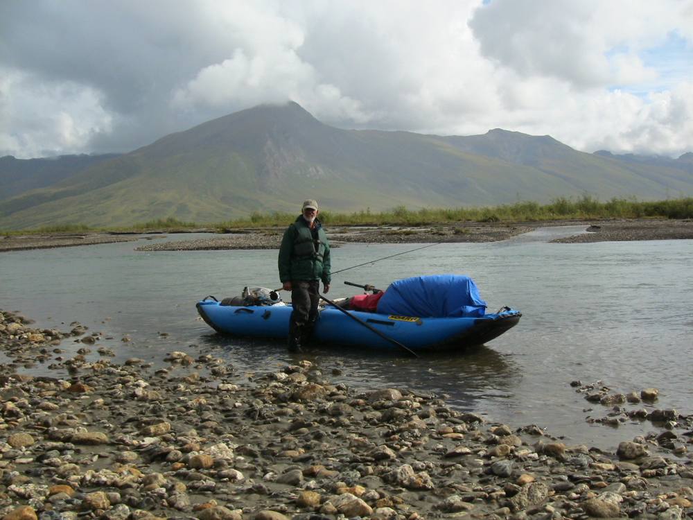
Soar Pro Pioneer, Upper Noatak
August 19: 67.51, 158.21. Buck is holed up today against fierce winds that have been blowing the last 2 days. The winds were so strong his heavy raft was even blown over, from where he had it propped up as a windbreak. His campsite today, though, is amidst 12′ tall willows, so he is completely sheltered. There is a good lookout knob near his campsite, and he’s gone up a couple times to have a look at things. On one such visit he saw a musk ox swim the river in kind of a meandering way. “He was floating just like a cork, and seemed to be enjoying himself and not in a hurry to get across.” Buck also saw about 10 caribou swim the river while he was sitting at his vantage point. The river has been going down steadily the last several days, and the fishing should be pretty good again once the wind stops blowing. Buck observed that though he wasn’t getting downstream as fast as he thought he would, he’s still making good progress.
I saw many caribou along the upper Noatak, including this big bull. He’s a member of the giant Western Arctic Herd which currently numbers nearly 500,000 animals! The largest of the many bands of caribou I saw numbered less than 15 animals.
Bull Caribou, Western Arctic Herd
Photo taken August 17
August 22: 68.08, 159.42. Buck got up this morning and saw a little creature swimming towards him across the river, which was about 200 yards wide. Buck stood and watched and saw that it was a little weasel, swimming over to investigate. The weasel came up out of the river, hopped around a bit as he examined Buck, and then disappeared into the bushes. All in a day’s work for a curious weasel. Later when Buck was floating along on the river he saw a musk ox plodding down the bank into the river. Buck was able to sneak closer in the raft and got some good video of the animal swimming the river and climbing out the other side. When Buck floated to that point on the river he looked, expecting to see the musk ox, but instead saw a startled 2-year-old grizzly come loping out of the bushes, flushed by the musk ox-quite a formidable animal! Buck looked down into the river at that point and in that pool saw hundreds and hundreds of chum salmon. Over the last couple days he’s seen 2 sets of 3 grizzlies: sows with their cubs. Buck was quite amused watching one of the cubs, saying that “he had 2 speeds: sprinting, and eating as fast as he could”. Buck has also seen lots of red foxes, and many caribou. He startled a big bull caribou by coming up silently in the raft, and the bull ran to within 15 feet of Buck. The fishing has improved, and he caught a nice char and several grayling. Tonight he will camp on the Nimiuktuk River. He is halfway done with the Noatak.
August 25: 68.00, 161.34. It’s been clear and beautiful the last few days, as Buck floats along the Grand Canyon of the Noatak. The name is “somewhat overstated”, but it is some nice scenery. Thursday night Buck had a very nice camp, and the fishing was quite good. Buck caught several grayling, 17-19 inches long, and hooked 2 big char but didn’t land them. Daytime adventures included drifting up on a musk ox. The ox stood his ground and kind of tried to pretend Buck wasn’t there, until finally turning to face Buck in his raft. “Musk ox don’t run away, their strategy is to stand and face the threat”. Buck also drifted up as close as he dared to a grizzly, keeping enough deep water between them that the bear couldn’t get him. When Buck got close, the bear crouched down, then started huffing and ran off into the bushes. Later Buck saw a caribou come sprinting out of the river going north (the wrong way for migration), and seconds later 2 more caribou came charging out of the area headed south. Then Buck saw what he thought was a black caribou running after them. “Black? I got out my binoculars and saw that it was a black wolf, chasing the caribou”. The drama paused as Buck drifted closer, and then he saw the black wolf stalking a caribou. The wolf started trotting, as another black wolf emerged from the bushes and started to chase the caribou. The fleeing caribou jumped in the river and swam right past Buck, pursued by the wolf, the predator so focused on the caribou that he got very close to Buck before he saw him, startled, and turned and went the other way. Meanwhile, the caribou made it to the other side of the river as the 2 black wolves trotted off, joined by a third wolf, a gray one. The wolves saw the caribou climb out of the river on the opposite bank and got pretty excited again, but didn’t start to chase. Buck got some pictures of all of this, and was thrilled with seeing such a dramatic scene. Friday’s camp was more good weather, very appreciated after all the horrible weather this summer. The fishing stayed good, with one cast bringing 2 seven-pound char very close, but no strikes. Buck was cooking an 18 inch grayling for dinner as we talked. The grayling had stuck the lure the second it touched the water, and Buck discovered 2 shrews and several small fish in its stomach. If grayling were bigger they’d be pretty scary. After the fish Buck was looking forward to a nice camp, on a beautiful evening, down in the black spruce.
Setting up camp was a daily ritual along the river. This was a beautiful setting and I grilled grayling next to the water that evening.
Making camp on the Noatak River
Photo taken August 25
I kept this 18 inch grayling. He had 2 shrews in his stomach!

Nice Arctic Grayling on the Noatak River
This was the black wolf I saw chasing a caribou while another black wolf tried to cut it off. The panicky caribou jumped into the river and swam right past my boat. I took this photo from the moving boat as he watched the caribou climb out onto the opposite bank.
Black wolf chasing a caribou!
Photo taken August 23
August 28: Happy birthday Loring! Today is Buck’s dad’s birthday, and both of us wish him a happy day! Buck is at the mouth of the Kelly River, and both the good fishing and the good weather have held for the last few days. For lunch, Buck cooked up a big char, several pounds, that he had caught this morning. The other day he was fighting a salmon, and looked up to see a musk ox observing him. The ox watched Buck for a bit, as it looked for a shallow place to swim the river. Buck also had another bear sighting similar to one earlier in the trip: He was walking towards a fishing hole when a grizzly caught sight of him and immediately started loping towards him. Buck got his camera out and started filming, until the bear got quite close. Finally, Buck shouted at the bear, which then turned and fled so fast it raised a dust cloud. About once a day, (not enough to be a bummer, he says) Buck has also been seeing native folks going up and down the river in their power boats. He says they are always quite friendly and wave and smile as they go by. Finally, he mentioned that the fall colors are really beautiful right now, and that combined with the nice weather has made for some very pleasant days on the river.
This was one of the bigger char that I caught on the Noatak. I hardly even recognize myself in a gray beard!
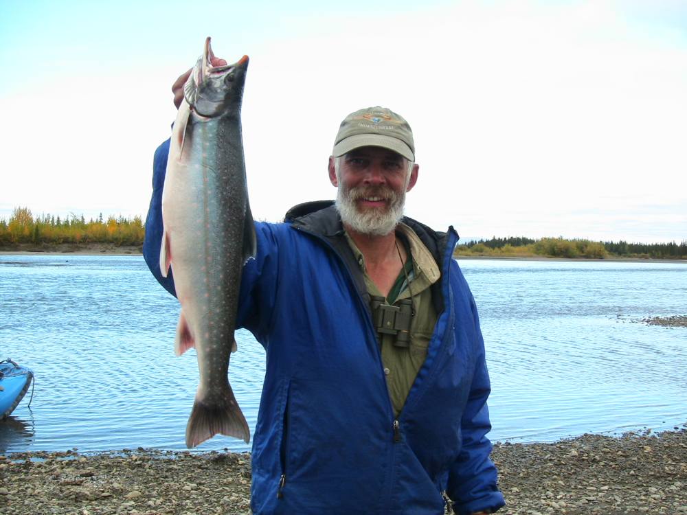
A fine Dolly Varden (Char)
Photo taken August 28
A nice char (or dolly, depending on who you ask) I caught on the lower Noatak. This fish weighed between four and five pounds according to weight/measurement charts I looked at.

Char, Noatak River
August 31: 67.16, 162.54. Buck is about 20 air miles from the ocean, but of course many more river miles than that. He passed through Noatak Village yesterday and picked up a camera that Marty had express mailed the day before: only 3 days ago Buck dropped his camera in the river, and though he didn’t lose any film, the camera was ruined. Perfectly timed, it seems, because he got hold of Marty in Fairbanks, who came to the rescue, express mailed his camera to Noatak, and Buck hardly missed a day of filming. Buck said the people in town were very friendly, but they had no newspapers, no restaurants, and no ice cream in less than gallon containers so he settled for a Pepsi and a few bananas. When he called he said there were about a dozen seals in the river, heads poking up out of the water, watching him. He’s a little surprised that they are so far from the ocean, but the chum salmon are running and the seals are chowing down. Buck has caught a few chum, still nice and silver and only starting to turn to spawning colors. He also caught a 25″ char the other day, which was quite fun. The river is getting smoother and much deeper now, but earlier in shallower sections the salmon were jumping constantly. Yesterday Buck saw a musk ox approach a bluff by the river, decide it was too steep a climb, and turn around and go the other way. Then a couple minutes later the musk ox was back at the same bluff, looking at it again with that same kind of “huh, can’t do it”. Turned away again. Last Buck saw as he was floating by, the musk ox was back for a third time in the same spot at the bluff…”I think they might not be very smart” Buck says. Last night he was scoping out the area around camp when he saw a grizzly coming towards camp. The bear hadn’t seen him, so Buck sprinted back to camp and got his rifle and his camera and filmed the bear coming up to the tent, then startling and running away. That night Buck woke to hear running by his tent, and in the morning woke to find grizzly tracks running between his boat and the tent, only about 25 feet from his head. This bear had gotten close to camp, smelled a person, and run away just like the other one. The days are getting shorter by about an hour a week now. The trip is drawing to a close, and winter is coming on fast.
This photo was taken at about 11 PM, on the lower Noatak, near the end of the trip. The sun would set very late in the evening.
On the second to last night of the trip I looked out of my tent door and saw my first stars of the fall. Appropriately, they were the Big Dipper. Sharing the sky was my first sighting of the Northern Lights for the season.

Noatak River Sunset
Photo taken August 30th
September 3: Fairbanks! Hello everyone, this is Buck. It’s nearly midnight and I just made it home to my cabin in Fairbanks, under the Northern Lights. I’ll have more to say tomorrow after I’ve gotten some rest, but it was a truly great adventure. I’ll also be posting some photos of the trip in the next couple of days, and adding more as time allows. I will also include a few more details from the last few days.
September 4: Back at the cabin. This is Buck again. As you can see, I’ve added a couple of new photos to the top of the page (with many more to follow.) They’re clickable, so you can make them larger. One is a view of the famous Arrigetch Peaks area. The second is the unusually colored wolf I saw in the headwaters of the Ivishak. This was the wolf that I spotted before he saw me. I sat down and got photos and video as he trotted by 25 yards away!
Well, the last update “from the field” that I called in to Melanie was August 31. The last couple of days on the Noatak the current was less than 1 mph, so I spent much of those days rowing. More cabins began appearing along the river. I saw many more seals, and when they were startled at close range when they’d come up to breathe, they’d often submerge with a great splash. There were more eagles and ospreys, and the fall colors were peaking. There were grizzly tracks (and often musk ox tracks) on most patches of mud along the river. At my last camp on the river, there was a gill net reaching perhaps 40′ into the river. That evening, a fellow came up on his boat and began pulling the net. I asked for permission to video the process, and he said it was fine. He’d caught 2 chums and a big char. He was very quiet, and I wondered if he didn’t appreciate me being there. But then as I walked away, he asked if I wanted to pick out a fish! We sat and talked. He was a local Inupiat Eskimo from Kotzebue. Naturally, he had lots of good stories. Just recently he’d seen a black bear swimming across the Noatak just below that point with the cub riding on the mother’s back! I was interested to hear he’d been a Marine, and had traveled “all over the world.”
On September 2nd, I launched my inflatable canoe and started rowing towards the mouth. The wind again kept me “crabbing” to keep from blowing over to the eastern shore. I’d put a radio in my last cache, so I pulled it out and picked up the Kotzebue station, and it looked like I’d be fighting a strong quartering headwind and waves while crossing the sound. With the wind and waves, and with those conditions predicted to last for days, it would take me hours to row across, and if the weather got worse… well, it just didn’t make sense to try to row across. As the river opened up to Kotzebue Sound, I landed the boat on the last island to finish my journey the way it had began, by hiking. I could smell the ocean as I walked nearly a mile to the salt water. At about 3:30 on September 2nd, the 77th day of my trip, I waded out into the salt water of the Chukchi Sea to end my journey. I’d hiked an estimated 615 miles and canoed about 403 more miles down the Noatak, for a total trip length of about 1,018 miles.
I’d gotten the names of 3 people from Kotzebue who shuttle people across the Sound. I gave one of those fellows a call and in an hour we were pounding our way across at high speed! The logistics of actually getting all my stuff home turned out to be more complex than I had anticipated. The air cargo offices weren’t going to open until Tuesday, this was Saturday) and my big barrel was too big and heavy to check in as baggage. Finally, I arranged for the same guy who’d given me my shuttle to ship my raft barrel and food barrel to me on Tuesday. Lots of logistics!
Thanks for reading the journal of my adventure!
Order my DVD here!


Great read- really enjoyed it and the pics. Thanks!
Thanks Matt! That’s mighty nice of you to take the time to let me know.