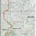
Desert Trail: Wallowa Segment
This segment starts out on FS Route 52, aka the Blue Mountain Scenic Byway. It enters on a trail through an old fire burn area of the North Fork John Day Wilderness. Now there are stretches of “hair on a dog’s back” regrowth. I took a left at the top of the Wilderness boundary, but that turned out to be a motorbike trail. I saw no motorbikes but rerouted these maps to a different trail that heads east, and then down. This might require a short cross-country jaunt in Section 11 of the Frazier map, below.
The route joins a FS road along Frazier Creek and continues on roads all the way to I-84. Most of the route is likely to have very little traffic outside of hunting season. The Frazier Creek vicinity is a popular OHV area though, and you will see some vehicles outside the wilderness.
There are some nice views in this segment. I saw many deer and elk and wild turkeys on this stretch along with really nice wildflowers. I found natural water sources periodically along the route.
You can read my journal entries of this segment starting here. The description talking about the motor bike trail and the “obstacle course” is not on the current route.
As roughly plotted digitally it is 48 miles long. Allowing for real-world twists and turns it is closer to 57 miles. This is a route, not a trail and there are no markers.
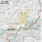
This segment is plotted on Google Maps below. YOU MIGHT HAVE TO ZOOM OUT UNTIL YOU SEE IT. You will also find maps that you can view online or print.
If you hike this segment of the Desert Trail, please report your experience below, including water sources, routefinding etc.
Desert Trail Intro
Desert Trail Guidebooks
Desert Trail Overview Map
My Desert Trail Journal
I have information on each of the new Desert Trail segments from Highway 78 in Oregon to Canada as seen below. For a rough digital map of that stretch of trail, click here.
Warm Springs: Highway 78 to Drinkwater Pass
Malheur: Drinkwater Pass to Austin Junction
NF John Day Wilderness: Austin Junction to FR 52
Wallowa: FR 52 to I-84
Umatilla I-84 (Exit 243) to Timothy Springs
Wenaha-Tucannon Wilderness: Timothy Springs to Dayton
Wheat Land: Dayton to Hooper
Columbia Plateau: Hooper to Spokane
Mt. Spokane: Spokane to Newport
Selkirk Mountains: Newport to Canada
View Desert Trail: Wallowa in a larger map where can download the .kml file if you want and convert it for use with most GPS units.