Desert Trail: Wenaha-Tucannan Wilderness Segment
Most of this segment is trail walking in the Wenaha-Tucannon Wilderness. This is one of the most wild and beautiful stretches of the whole Desert Trail and I highly recommend it for experienced hikers. There are long walks along rivers and creeks and good views at times up high and unlike much of the Desert Trail there is a lot of constructed hiking trail.
I will never forget the mountain lion that leapt out of the tree and ran away nor the wildflowers and the sunset on the knife edge ridge shortly thereafter.
There were two confusing sections of trail. One was where the trail had slid down into the river and I had trouble picking it up again as I assumed it had crossed the river. The second is where the route leaves the Wenaha River and climbs north toward Weller Butte. I discovered the trail is long since abandoned. It was fairly easy going climbing the mostly open hillside before picking up trail again on top. Along the way thru-hikers will be thrilled if they spot the white “Washington” sign. Once back on the trail (some in need of repair) you can follow it all the way down to the Tucannon River. From Panjab Campground, a pleasant place to camp, the route follows roads to Dayton. Dayton has food and motels but no laundromats that I could find.
It took me about 3 1/2 days to hike this section. Water should not be an issue except climbing from the Wenaha north up the ridge.
You can read my journal entries of this segment starting here.
As roughly plotted digitally it is 55 miles long. Allowing for real-world twists and turns it is closer to 69 miles. This is a route, not a continuous trail and there are no Desert Trail signs.
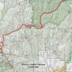
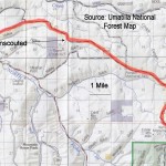
This segment is plotted on Google Maps below. You will also find maps that you can view online or print.
If you hike this segment of the Desert Trail, please report your experience below, including water sources, routefinding etc.
Desert Trail Intro
Desert Trail Guidebooks
Desert Trail Overview Map
My Desert Trail Journal
I have information on each of the new Desert Trail segments from Highway 78 in Oregon to Canada as seen below. For a rough digital map of that stretch of trail, click here.
Warm Springs: Highway 78 to Drinkwater Pass
Malheur: Drinkwater Pass to Austin Junction
NF John Day Wilderness: Austin Junction to FR 52
Wallowa: FR 52 to I-84
Umatilla I-84 (Exit 243) to Timothy Springs
Wenaha-Tucannon Wilderness: Timothy Springs to Dayton
Wheat Land: Dayton to Hooper
Columbia Plateau: Hooper to Spokane
Mt. Spokane: Spokane to Newport
Selkirk Mountains: Newport to Canada
(Zoom out the map if necessary to view this segment of trail, designated by a green line.)
View Desert Trail Wenaha.kml in a larger map where can download the .kml file if you want and convert it for use with most GPS units.