
The Desert Trail
The Desert Trail is a 2,223 mile hiking route from the border of Mexico in California to the border of Canada near the Idaho/Washington state line. In 2012 I thru-hiked this route from March 1 to July 11. It was one of the greatest adventures of my life.
If you are going to hike any part of the Desert Trail, you’ll definitely want to check out the info from Buck30’s 2019 thru-hike:
Buck30’s Desert Trail Summary and Planning
CLICK HERE for the stories and photos at my Desert Trail thru-hike journal.
The Idea
Many years ago I spent my first summer out West fighting wildfires and working with the wild horse program in Rock Springs, Wyoming. I loved the wild country of the West. It took a while for the desert to grow on me, but now I appreciate the desert for itself, especially the more remote areas. There was an idea of hiking a desert route from Mexico to Canada in my head and I began laying out potential alternatives. That’s when I stumbled upon the Desert Trail.
Planning
Russell Pengelly started planning for the Desert Trail way back in the early 60s with the hopes of developing a route all the way from Mexico to Canada. A great deal of progress has been made, with routes selected and guides or maps produced from Mexico to eastern Oregon. In the summer of 2011 I started planning to hike this route. “Seldom Seen” got me started with contact information for many knowledgeable people and confirmed he could provide the route maps for southern Oregon and just across the border into Nevada. Then in very late 2011 everything started coming together. Bob Lyon of the Desert Survivors provided me with a wealth of planning information, Steve Tabor rounded up copies of all his outstanding guidebooks, George Huxtable mailed me his guidebook for Death Valley. Dave Oline copied and sorted old Desert Survivor newsletters, and provided me a kml route as well as other invaluable info. Gerry Goss provided me with more route data. Suddenly it was all coming together fast.
Steve Tabor, author of numerous Desert Trail guidebooks says this: The Desert Trail passes north from the Mexican border through the deserts of California, Nevada, and Oregon. It is not a constructed trail, but a hiking corridor the hiker/backpacker may use to access some of the West’s most remote and fascinating territory. The California Section of the Desert Trail passes through four parks and seven Wilderness Areas in the southeastern corner of the state… The Nevada section of the Desert Trail passes through ten Bureau of Land Management Wilderness Study Areas and two National Wildlife Refuges in the western third of the state.
In Oregon the Desert Trail passes through the Pueblo Mountains, the Alvord Desert, over Steens Mountain, and through the Malheur National Wildlife Refuge. The route I pioneered continues up through the Blue Mountains including the Monument Rock Wilderness, the North Fork of the John Day Wilderness, the North Fork of the Umatilla Wilderness and the Wenaha-Tucannon Wilderness of Oregon and Washington. The route continues through some wheat country to Dayton, over Little Goose Dam, then follows the Columbia Plateau Trail, passes through Spokane and over Mt. Spokane. After a resupply in Newport the route traverses through the Selkirk Mountains and the Salmo Priest Wilderness to finish in a spectacular setting just east of the Washington/Idaho/Canada border.
The original intent of the Desert Trail Association was to plan a route from Mexico to Canada. The route had been planned and mapped from Mexico to Highway 78 in Oregon through the efforts of Steve Tabor and many others. The route I planned from Highway 78 to the border of Canada has since been designated as the official route of the Desert Trail. “Hike Your Own Hike” rules on this route. Your route is your Desert Trail.
The Desert Trail Association’s announcement originally appeared in the Madras Pioneer as quoted below.
The Desert Trail Association, based in Madras, has finalized and mapped a hiking trail that touches both borders with Canada and Mexico.
Simply known as the “Desert Trail,” the route covers more than 2,200 miles, and begins near Jacumba, Calif., on the U.S.-Mexico border, and ends at the U.S.-Canada border near Selkirk, Wash.
It winds through the Mojave Desert, up through Death Valley, then into Nevada and the Black Rock Desert and continues north. From there, it enters Oregon through the Pueblo Mountains, and through the Alvord Desert and Steens Mountains, before it reaches the Malheur National Forest.
The trail continues through the Umatilla National Forest, past Vinegar Hill and crosses Oregon Highway 224. It passes through the Mount Emily Wilderness Area near Hilgard, then takes a turn toward Tollgate and crosses into Washington.
Once in Washington, it runs through Dayton, and then up to Cheney and Spokane before making one of two brief appearances in the Idaho panhandle. The trail returns to Washington for its big finish, up to the Canadian border near Selkirk, Wash., but runs back into Idaho for the end of the trail.
Bruce “Buck” Nelson, the first person to ever hike the entire trail, made the trip in a single traverse and provided the verification from on the ground. He is a retired smokejumper from Anchorage, Alaska, and began the trek in March 2012. He finished the hike on July 9 of the same year.
The trail incorporates some existing trail routes, wilderness sections and plenty of open deserts, said Dave Green, past president of the DTA.
Green, of Madras, pointed out that unlike the popular Pacific Crest Trail, the Desert Trail features point-to-point navigation, which Nelson provided the bulk of during his journey. Extensive map studies, along with help from the Bureau of Land Management – and other public land-use agencies – also contributed in finalizing the mapping of the route taken by Nelson.
A point-by-point map of the route, using Google Maps, can be found at Nelson’s website, www.bucktrack.com.
.
Cross-Country, Trails and Roads
The official Desert Trail has been designed to be hiked in segments of 12-42 miles in 2-4 day intervals, so it is very possible to have a wonderful desert adventure during a single weekend. There are about 656 trail miles in California and 685 miles in Nevada. There are about 159 more miles to Highway 78 in Oregon. There were about 723 miles in the route I planned from that point to the Canada border, for a total of about 2,223 miles.
There is very little constructed trail along most of the route. As a matter of fact, no trail has been constructed specifically for the Desert Trail to the best of my knowledge. The route is mostly cross country walking through desert, washes, across dry lake beds and along ridge lines. In places the route follows wild horse and burro trails and 4WD trails. In some places the route follows gravel roads. Most “road-walking” is in places where vehicles are rarely seen. There are relatively short stretches along paved roads here and there linking the wilder country, and only in a short stretch north of Spokane and another around Newport did I find traffic annoying. Logging roads are used extensively in Oregon and Washington. I hiked some Forest Service roads in the Blue Mountains just as the snow was melting, so there were hardly any vehicles for long stretches. Most of the Forest Service hiking trails were in the Umatilla and Colville National Forests. Obviously hiking over 2,000 miles is considerable work any way you cut it, but although there are hundreds of miles of cross-country travel most of it is fairly easy going and there is less climbing than on any of the well-known “Triple Crown” trails.
Until the last day I saw backpackers only once all summer. In a few places like Death Valley there were day-hikers out. Most days I wouldn’t talk to a single person.
Hike Timing and Weather
I decided to start my hike March 1. Others had told me the first serious snow I’d hit during late spring would likely be on Steens Mountain. That proved to be accurate. I was surprised to encounter snow several times before that, though, hitting one of two short-lived but significant snowfalls of close to a foot before the Blue Mountains. There was snow in the Blue Mountains but not a serious problem. There was also enough snow to add to the challenge near the Canada border, but only for the last couple of days. Had I started earlier snow would have been a bigger problem. I certainly hit plenty of heat, but not nearly as hot is it could have been, or almost certainly would have been, if I had started later. I think the highest heat I hit all summer was in the mid-90s. Having access to plenty of water is vital. A wide-brimmed sun hat or a shade umbrella would be wise to have as far as Oregon or so. When it’s hot, starting early in the day and hiking late and taking advantage of shade during the heat of the day works well for many people. If I were to hike the trail again I’d start about the same date unless the snow was unusually deep. One of my biggest surprises was how chilly it was along the trail at times. I had a warm down jacket and was mighty glad to have it. I had a shelter and rain jacket the whole trail and needed them as it rained or snowed several times in the desert.
Water and Food Caches
Caching supplies and/or vehicle support are necessary at least to Oregon, in my opinion. There are very few sources of dependable water up until that point. Since I was driving the route caching water anyway, I cached food as well. To lighten my pack and for the safety of redundancy I used numerous caches. That way it would be easier to get to the next cache if one was unrecoverable. Also, of course, in most cases I could have made it to a road for a “Plan B” if necessary. Staying hydrated would be crucial. Most of my caches were buried in place that wouldn’t be easily spotted by the curious. Normally I’d bury them with at least 1″ of dirt over them with a big rock on top if available. I had a system of marking the buried cache with stones, in such a way that I could recognize it but it wouldn’t draw attention. Water was buried in 1 gallon jugs or smaller bottles. Some canned food was buried “as is” (no bears in the desert.) Most food was buried in .50 cal. “ammo cans.” Every cache had water, but not every cache had food. Out of all those caches only one jug of water came up missing. Best guess: a coyote dragged it away. Marker rocks were mysteriously moved at two other caches. Otherwise the caching went great. If I did it again I’d be more aware of the winds blowing loose dirt away and bury the caches with at least 2″ of dirt over them. With several I could see the blue caps of water jugs sticking out when I returned. On at least two foxes or coyotes had scratched them curiously. I had a wide “sand” tent-stake to help me in digging up caches although of course I used a real shovel to bury them.
I chose spots near recognizable points, say near a big boulder where the route crossed a road. I really needed to find those caches! I primarily used my iPhone with GPS to mark them, but had another GPS as backup. I took a photo of each cache site, and kept paper notes of the cache contents along with a written description of where the cache was.
I’d planned to cache only the first 500 miles of trail. There are always lessons to be learned and the reality is most hikes end early, so I was reluctant to put out too many at first. But public transportation was so scarce I decided to cache the first 1,000 miles of trail. It took me a day or two to purchase food and water, and about a week to lay out 54 caches from Lovelock, NV to the border of Mexico. After hiking that first stretch, I took a bus back to San Diego and got a ride back to the start of the PCT and actually hiked back to Jacumba where I retrieved my pickup (parked with permission of the good folks at Jacumba Hot Springs Spa & Lodge) and retrieved all my used caches, often with any nearby pieces of trash for good measure. From Lovelock, I cached north to Drewsey, Oregon. North of there water would be relatively plentiful so I hung a handful of caches in trees (bear country) to the LaGrande area. Beyond that it would be a standard thru-hike where I’d walk or hitch into town for resupply.
I think I only actually hitched 3 times, in and out of Hawthorne, NV, and into Burns, OR, where I got a ride back to the trail with friends. I have heard since that hitch-hiking is illegal in Nevada. That was interesting because a policeman was parked a hundred yards away from me as I hitched out of Hawthorne! In addition to caches and those few hitches I walked right through a few resupply points, like Mecca, CA; Stovepipe Wells, Death Valley; Luning, NV where there are no stores but a mail drop is possible; Lovelock, NV, a good resupply town; Fields, Oregon; Denio, NV for a Post Office; the Drewsey, OR Post Office; the Austin House Café & Country Store in Oregon; Dayton, the Hooper Post Office, Cheney, Spokane and Newport, WA. I had packages held for me at a few places like the Tecopa Hot Springs County Park, Kelso Depot, and Stovepipe Wells. Make sure you verify the WHO and WHERE if leaving packages as weeks or months later it might be long forgotton! Also make sure you verify all your mailing points. The Chiriaco Summit Post in California returned my General Delivery package to sender because I didn’t “let them know ahead of time” that it was arriving!!!
How Long Did it Take?
I left the border on March 1, and got to Canada on July 11, so it was a total of 4 months and 11 days. That included about 16 days mid-trip picking up empty caches and laying out a new set of caches. And of course, there was another ten days or so leading up to day one for food buying and caching, and about three days after the trip picking up used caches. For comparison, I did the Appalachian Trail in about 4 months and 4 days, the Continental Divide Trail in about 4 months 23 days, and the Pacific Crest Trail in a day short of 5 months.
Snakes and Animals and Birds
There were countless quail and birds of all kinds, including scores of eagles. I think I saw only 3 rattlesnakes all summer. Snakes should be respected but not feared. There were lots of lizards. I didn’t see any scorpions. I saw many desert bighorn sheep, antelope, wild horses and burros, coyotes, foxes, deer and, in the timber country farther north, elk, a bobcat and a cougar. I didn’t see a bear although there were bears in stretches from central Oregon to Canada. Sometimes wildlife seemed scarce, at others it was abundant.
Artifacts and More
I found dozens of artifacts, including stone projectile points: arrowheads, spear heads, atlatl; stone knives and scrapers, pertoglyphs and pictographs. Sometimes there’d be nothing for many days and then I’d find the ground littered with flakes from ancient tool-making. There were also more modern artifacts from miners and pioneers, including a few old cabins in lonely places. I found a petrified log and many smaller pieces as well. I left all these items where they were as required by federal law and for others that follow to enjoy. There is always something to see if you’re interested. The Tabor guidebooks were great for explaining flora and fauna and geology. The desert is barren and boring to those that don’t pay attention and appreciate what it has to offer.
Landscapes and Ecosystems
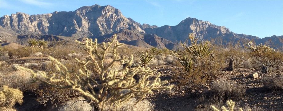
The route passes through several deserts and ecosystems, including the Colorado Desert, the Mojave Desert, The Great Basin, semi-desert lands, the Blue Mountains, the Columbia Plateau, and the Selkirk Mountains. An especially good treat for thru-hikers are the hot springs along the route, both wild and developed, a half dozen or more. Apart from pinyons and junipers and Joshua trees there are few trees until Oregon. Starting in the Blue Mountains the route passes through many stretches of big timber. If you follow the whole route you will encounter cold weather and hot weather, baking desert and snow drifts, rattlesnakes and salmon.
Further Advice
This is the first hike where I used a smart phone; for a camera, GPS, star chart, updating my journal, email and phone, even ordering supplies to be delivered ahead of me. Coverage was spotty, but I was usually able to update my journal every day or two, generally, with some significant gaps in places around Death Valley, the Stillwater Mountains, north of the Black Rock Desert, etc. I used AT&T and I was banned, permanently, from using any off-network data because I used about 100 MB off network during the course of the summer! Luckily that didn’t take effect until after my hike. AT&T was not into supporting my hike, that’s for sure. This is a hike were some type of PLB or SPOT device might be a good idea for those gaps of no coverage and no water. This is a trail for independant thinkers with good judgment, as you will be self sufficient most of the time unless you have hiking partners with you.
Please see the journal of my hike, my gear list, a list of available guidebooks and a map of the trail at the top menu under Thru-Hikes>Desert Trail
If you have questions or comments, you are welcomed to ask them below.
If you like this page, please “like” it!