Thru-hiking, paddling, climbing, hunting, fishing, gear lists, tips, and more.

Month: July 2016 (Page 3 of 9)

Mann Gulch, Gates of the Mountains

July 24, Day 123, Mile 2,243

As of this evening I have been on the Lewis and Clark Trail for four months. Today was an important day in other ways as well. 

My campsite last night was wonderful, deep ponderosa pine needles for a bed. What wasn’t so awesome was the very loud music coming across the water from somewhere. It stopped suddenly at midnight. 

It gets light earlier, seemingly, sleeping without a tent. The big pine protected me from the dew. All my clothes, except for my shoes, were dry. 

It was calm for a few minutes until a headwind arose. But, compared to the strong headwinds and powerful currents I have been dealing with, I flew across the water. 

At first I had the river completely to myself. Mule deer drank at the waters edges or in the meadows. Bighorn sheep fed in the cliffy areas. Eagles were so common they are hardly worth mentioning. 

At 9 AM I’d come 13 miles. Nearly as far as I’d come each of the last two days. Ahead towered The Gates of the Mountains. 

Approaching Gates of the Mountains


Here was the sign for Mann Gulch, the site of the worst disaster in smokejumper history, a place where 13 men lost their lives. Having been a career smokejumper, and having jumped Montana many times, this was an especially meaningful place to me. 

There was a good spot to land my kayak in the shade of the cliff. I grabbed my daypack and some water and headed up the gulch. 

After about 30 minutes I could see the first crosses high up on the slopes, slopes that burned so hot on that August, 1949 day that the vegetation hasn’t come close to recovering, burned tree trunks still standing here and there. 

As is typical with most wildland fire tragedies, fire got below them and blew up. All but three lost a race to the ridgeline, and safety. The foreman lit an escape fire and lay in the burned area, and survived while most of the others who failed to follow his example did not. Only two made the ridge in time. 

I’d forgotten how scattered the crosses were. I remembered how close some of the dead had come to making it out. It only took me about a minute to reach the ridge from the highest cross. It was all too easy to look at the steep topography and think about that dry forest on that record-hot day and imagine how it had all happened. 

Someone had hung smokejumper wings from each marker. Some markers had other items: a hard hat, coins, a small memorial from family. 

David R. Navon’s Marker, Mann Gulch


David R. Navon, USFS Smokejumper, Lt., 82nd Airborne and 101st Airborne. Jumped D-Day, Operation Market Garden, fought at The Bulge. Jumped Mann Gulch. 

The reflective mood of my lone hike up Mann Gulch was broken back at the river. A tour boat pulled up while the people listened to a short speech. Powerboats raced by. Around the corner was some of the very most spectacular scenery of the whole summer, incredible towering cliffs. But for me most of the magic was shattered by roaring boats screaming by me. 

After a few miles I left the boats behind, and a serene loneliness returned for a few miles.  Near Hauser Dam I began to see many bank fishermen. It looked like beautiful trout water. The current got faster and faster but I managed to paddle through it. 

“Where did you start, Beaver Creek?”

“St Louis.”

“St Louis!?” When I confirmed he wished me safe paddling and I wished him good fishing. 

At the pullout a 3 year old boy watched me strap the cart on my kayak with intense interest. When I started pulling it away he was thrilled. When I turned to look back he waved shyly. 

It was challenging to get down the very steep bank on the other side. I completely unloaded the boat to do so. 

It was a powerboat madhouse on the lake, everyone going full speed, many blaring loud music. 

When I hit 30 miles and spotted an idyllic camp spot I decided to call it a day. Roaring boats, pounding music and yelling drunks affected the ambiance until late evening, when nature ruled again. Colter

Lewis: …July 19th 1805 The Musquetoes are very troublesome to us as usual… this evening we entered much the most remarkable clifts that we have yet seen. these clifts rise from the waters edge on either side perpendicularly to the hight of 1200 feet. every object here wears a dark and gloomy aspect. the towering and projecting rocks in many places seem ready to tumble on us… from the singular appearance of this place I called it the gates of the rocky mountains.

Lewis: July 20, 1805… I saw a black woodpecker today about the size of the lark woodpecker as black as a crow. I indevoured to get a shoot at it but could not. it is a distinct species of woodpecker; it has a long tail and flys a good deel like the jay bird. This morning Capt. Clark set out early and proceeded on through a valley leaving the river about six miles to his left; he fell in with an old Indian road which he pursued untill it struck the river about 18 miles from his camp of the last evening just above the entrance of a large creek which we call white paint Creek. the party were so much fortiegued with their march and their feet cut with the flint and perced with the prickly pears untill they had become so painfull that he proceeded but little further before he determined to encamp on the river and wait my arrival.—Capt. C. saw a smoke today up the valley of Pryor’s creek which was no doubt caused by the natives…

Trip overview and route map with position updates: 

https://bucktrack.com/Lewis_and_Clark_Trail.html

Cowboy Camping

July 24, Day 123, Mile 2,213

The sound of the river is part of my world, day and night. There are few sounds more conducive to a good night’s sleep and last night was no exception. 

My getaway was more relaxed today. I have a homemade coffee/mocha mix that I drink cold. I sipped it as a lounged a bit longer in my warm bag. Then there was, as usual, the donning of wet pants, wet socks, wet shoes. Until I got my temporary cheap shoes, I was forgoing the socks. 

It was again a winding river with looming dark cliffs. And again it was a big day for mink, and today, muskrats. Today’s headwind wasn’t as bad. Fishermen were out, and this being a Saturday, this scenic section of river attracted many floaters, which I first started seeing in late morning. 

At Craig I landed my kayak in a carnival atmosphere of people getting ready to launch. One guy asked me where I started. When I told him he was amazed and delighted. 

I walked to a little restaurant. They weren’t afraid to charge big. For example, they had an “ATM” that charged $4 for $40 max. An instant 10% sounds pretty high!  Despite paying double, I had a good burger. 

The geese were so accustomed to floaters they were barely getting out of the way. 

I made it to Holter Dam around 4. I completely emptied, cleaned and reloaded my kayak. After getting some water I attached the cart and made the portage of less than a mile. Pretty steep at the end. 

It seemed like a long time since I’d been on a lake. Across the lake were real mountains, thousands of feet high. The wind suddenly turned to a tailwind with enough waves so I almost wished I’d put on the spray skirt. 

I paddled a couple more miles and decided to camp about 6 pm. There was a nice spot under a big Ponderosa, too small for a tent though, drat. Then it struck me: I don’t need no stinking tent, OR sleeping pad! I’d do what I’d been looking forward to: cowboy camping on pine straw. 

Cowboy Camping

It was another day with some hard miles, but I still made 15 miles, including the portage. Colter

Lewis: Thursday July 18th 1805. Set out early this morning. previous to our departure saw a large herd of the Bighorned anamals on the immencely high and nearly perpendicular clift opposite to us; on the fase of this clift they walked about and hounded from rock to rock with apparent unconcern where it appared to me that no quadruped could have stood, and from which had they made one false step they must have been precipitated at least a 500 feet… as we were anxious now to meet with the Sosonees or snake Indians as soon as possible in order to obtain information relative to the geography of the country and also if necessary, some horses we thought it better for one of us either Capt. C. or myself to take a small party & proceed on up the river, some distance before the canoes, in order to discover them, should they be on the river before the daily discharge of our guns, which was necessary in procuring subsistence for the party, should allarm and cause them to retreat to the mountains and conceal themselves, supposing us to be their enemies who visit them usually by the way of this river. 

Trip overview and route map with position updates: 

https://bucktrack.com/Lewis_and_Clark_Trail.html

Into the Rocky Mountains

July 22, Day 121, Mike 2,198

There were plenty of mosquitoes outside my tent, but they were lethargic from the morning chill.  I heard some familiar bird calls, but couldn’t place them until I remembered it was Clark’s Nutcrackers. 

Fast current/rapids alternating with slower pools had me out of the kayak most of the day. 

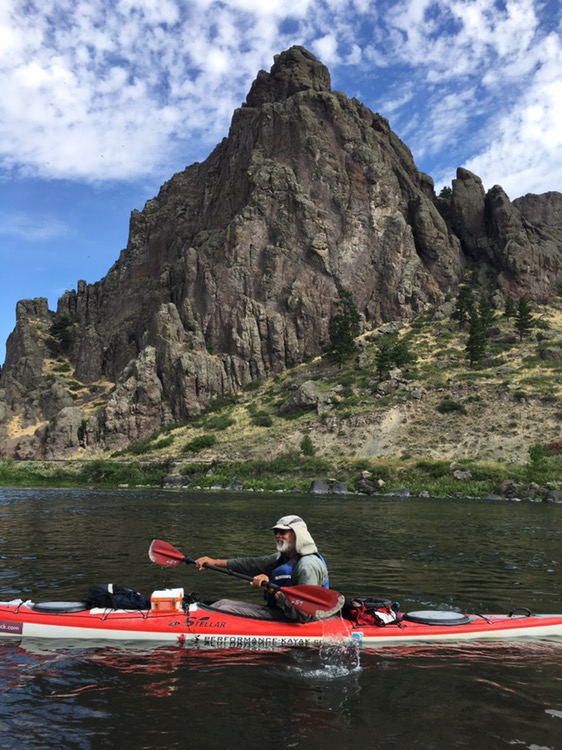
Today I entered the Rocky Mountains and, like Lewis and Clark, was impressed by the dark, rugged cliffs looming over the river, truly some of the most dramatic scenery of the trip. A bighorn ram stood silhouetted on a ridgeline. 

Paddling into the mountains


Very fast current rushed past a boulder on the bank, forcing me to paddle around it. When my kayak hit the much faster current, water piled up, threatening to flood my cockpit. I quickly leaned away to prevent it: too far. For the first time on the whole trip I capsized. It was a big surprise. I quickly got out and got my feet on the river bottom and righted the boat, taking a quick look to make sure nothing was floating away. 

I pulled the kayak over to a tiny grassy island. Somehow there was only a little water in the cockpit which I sponged out. The hatches hadn’t leaked. Everything was secure. The water hadn’t even been that cold. Other than whacking my left shinbone on the edge of the cockpit, it was about as inconsequential as it could have been. 

The river alternated between having a wilderness feel and seeming busy. It passed under I-15 several times. There were a number of fishing boats and even more floaters, some in huge rafts, some in tiny boats of various kinds, one in an inflatable pink flamingo. 

At one corner a plastic bottle came flying out of the willows into the river, just thirty feet ahead. I grabbed it and paddled around the corner. An old guy was messing with a small tractor. 

“Did you just throw this in the river?” 

“It must have rolled into the water.” That was, for sure, a bald-faced lie. I flung the bottle at his feet and kept going as he berated me, obviously angry about being caught red-handed. The river is so trash-free his behavior was really surprising. 

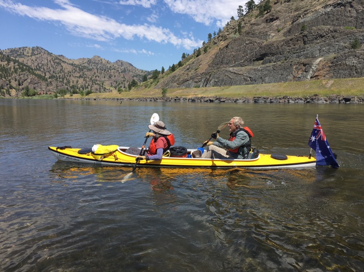
I was watching for a yellow kayak today and spotted it easily. It was Bob and Barb Bellingham of Australia. They were paddling to Kipp Landing. Bob had paddled the whole river in 2012. We landed and had a long conversation about paddling and the Pacific  Crest Trail, which we all had hiked in 2010. It was an enjoyable rendezvous. 

Bob and Barb


I saw two mink today. The first watched half hidden in the willows, so close I could nearly have touched him with a paddle. 

The wind blew hard most of the afternoon. A headwind. I’d often have  to rest before paddling through especially fast, deep water where I couldn’t pull. 

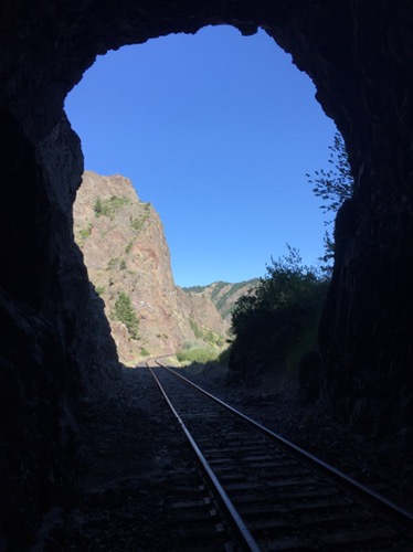
I camped on a willow island near dark cliffs and an abandoned railroad tunnel. These were some of the toughest miles of the trip, but I managed to eke out about 15 miles. Colter

Railroad tunnel


Clark: July 17th Wednesday 1805 Set out early this morning and Crossed the rapid at the Island Cald pine rapid with Some dificuelty, at this rapid I came up with Capt Lewis & party took a Medn. altitude & we took Some Luner Observations &c. and proceeded on, the emence high Precipies oblige all the party to pass & repass the river from one point to another the river confined in maney places in a verry narrow Chanel from 70 to 120 yards wide bottoms narrow without timber and maney places the mountain approach on both Sides, we observe great deel of Scattering pine on the mountains, Some aspin, Spruce & fur trees took a meridian altd. which gave for Lattitude 46 ° 42′ 14″ 7/ 10 N we proceeded on verry well about 8 miles & Camped on the Stard Side The river crooked bottoms narrow, Clifts high and Steep, I assended a Spur of the Mountain which I found to be highe & dificuelt of axcess, Containig Pitch Pine & Covered with grass… Saw Several Ibex or mountain rams to day

Trip overview and route map with position updates: 

https://bucktrack.com/Lewis_and_Clark_Trail.html

« Older posts Newer posts »

© 2024 Outdoor Adventures

Theme by Anders NorenUp ↑