
August 14 Somewhere out in this tangle of creeks and lakes and bog and tundra is the Johnson River, and today I’ve got to find it. I’m hoping that if I search south for a mile or so I can intersect the channel. If it’s dried up… well, I guess I’ll have to find another way.
On a whim, I decide to explore east for a few hundred yards. From a ten foot high tundra ridge I spot a bit of open water. I wade out and find what was probably the river channel way back when. It’s floatable here. Hopefully I can follow it to something that looks like a real river, or at least a creek.

It’s a quarter mile portage to the water, done in three carries. There’s the usual flounder through floating bog to get to open water. I hop in the boat and begin paddling. I’m hopeful, but I’m going to wait to celebrate until I see a good current.
Several times it looks like the channel disappears into the grass, but every time I’m able to weave around and paddle on. There’s a bit of a headwind but that’s the least of my concerns. The meandering channel leads me out into a lake. I paddle for a few hundred yards, looking for an outlet but don’t find anything. I don’t remember the river running through a lake on the map. I check my location on the GPS map and it shows that I’m off the river channel. I must have missed the turn where the river ran through tall grass?
I paddle back upstream for a half mile, watching carefully for the channel or current leading through the vegetation. I see nothing. There’s a low knob with a birch tree growing on it. I pull the boat up into the grass, mark it with my paddle standing on end, and wade over to the knob where I climb fifteen feet up in the tree, nearly to the top. The river should be close. There’s no sign of it. My heart sinks.
I slog back to my kayak and paddle downstream, watching my GPS until I get to where the river is plotted. I get out of the boat and walk through the ankle deep water. Here, I find the old channel. There’s almost no water. This is not good.
The smart bet seems to be to follow the weak current that runs into the lake, and try to follow any current to whatever river I can find. I paddle back out into the lake and follow the right shore. I can’t find any current running out of this lake. I land the boat and climb up on a low hill but if there’s a river in any direction, I can’t see it. I consider a cross-country portage, but it seems like a huge amount of work getting to an old channel that might be dry.
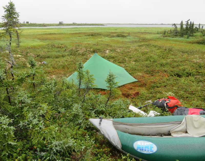
Back in the kayak I continue scouting. Suddenly the wind starts blowing so hard I can barely paddle. Then a downpour hits. The wind whips the rain into my face. I land the boat at the highest ground. There’s so sign of the rain letting up so I set up my tent in the rain, then climb in. The rain has blown in around my rain jacket hood, and run up my sleeves so my torso is pretty wet. My legs and socks are sweaty from working so hard in the swamps and the humidity is 100% and it’s still pouring. I take off my wet clothes and crawl into my sleeping bag.
I look at my iPhone mapping program to make a plan. I can see the map, but the GPS isn’t working, so it doesn’t plot where I am on the map. Now that’s a new problem I haven’t encountered before. My formerly waterproof GPS has some condensation inside it, and I find that the GPS has stopped working on it, as well. Now what are the odds of that!? Rarely have I needed a GPS more than I need it now. The odds of both failing at once are astronomical.
As usual, there’s a Plan B. I have my inReach satellite communicator. I get my coordinates from that. I use the maps on my other two devices trying to figure out an alternate route through the myriad lakes. Tomorrow I’ll search once more for a detectable current running out of this lake.
This is close to a perfect storm of challenges. For one thing, it’s literally storming. For another, the river I need to follow is missing. Then there’s the failure of my GPS units, and the fact that, even if I hit the old channel further down, it might be choked with vegetation and un-navigable for the next twenty miles, plus there’s no telling if there is water in the next ten miles or so of Crooked Creek beyond that. And if I can’t find a route forward, it will take five or six days to get back to the Yukon, having failed to complete the portage. The dark sky and hammering rain, the heavy, wet air, and condensation running down the inside of my tent fly doesn’t boost my morale any. Right now, I’d guess I have a 50/50 chance of making it through to the Kuskokwim River.
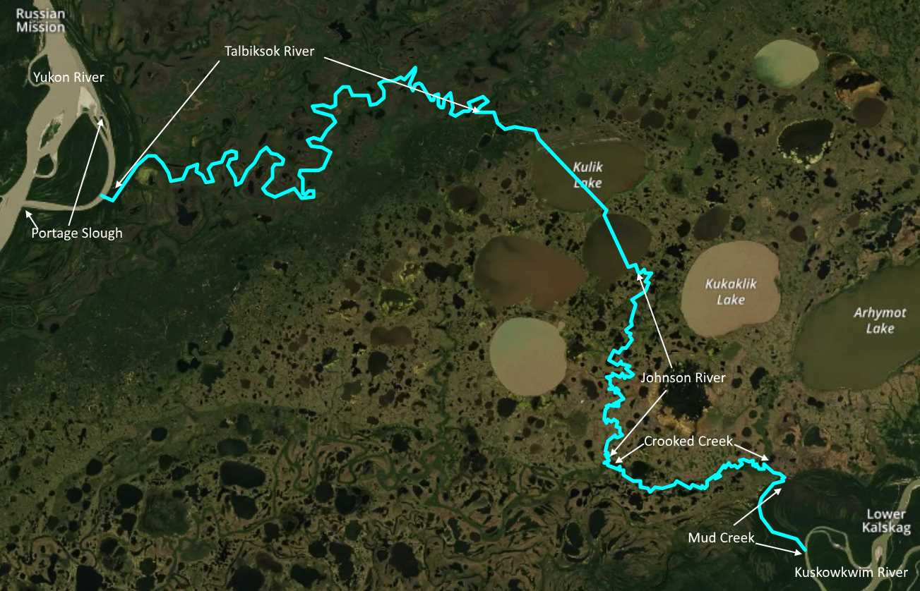
(Tonight I am camped on an unnamed lake, off the plotted route, west of Kukaklik Lake. The whole portage is about eighty miles.)
I’m adding a new post once a week or so. Check back for more!
Hey, don’t leave us hanging!
You’ll have to tune in next week.